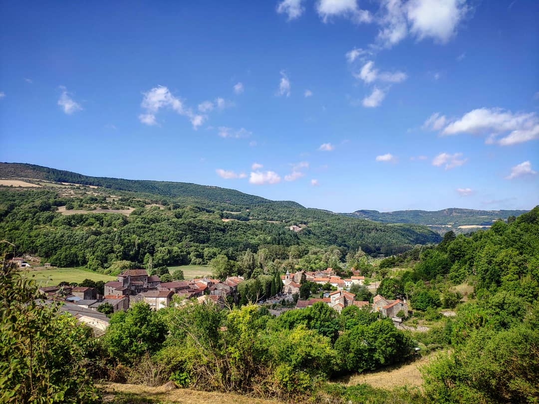
Versols hiking circuit "A path, a school"
From the fountain to the Cinzelles electric power station, from the castle to the formerly cultivated terraces, from the 14th-century bridge to the Montgrand cliffs where birds of prey nestle. Go and explore the village of Versols and its surroundings, from the old battlements to the Larzac foothills.
2 points of interest
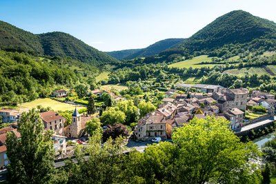
Village de Versols - Xavier Waerzeggers  History and heritage
Village of Versols
The village of Versols has a rich history dating back to the Middle Ages. Its fortified settlement, built on a slight ridge at the junction of two valleys, succeeded an earlier Gallo-Roman site and once overlooked the major medieval route to Lodève.
Today, the village still preserves many traces of its defensive past, including a fortified gate, a tower, sections of ramparts, and elegant mullioned windows. Its main street and postern gate reflect the medieval layout of the settlement.
Versols is also home to the Church of Saint Thomas, while nearby stand the former Priory of Our Lady of Cayla and the Château de Montalègre, built in the 13th century.
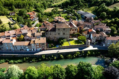
Château de Versols - Xavier Waerzeggers History and heritageCastle and Fortification Remains
For nearly eight centuries, from 1250 to 1810, the castle was home to the Roquefeuil family. After leaving the family’s ownership, it passed through several hands, and part of the complex was converted into a farm. The estate was eventually repurchased by the Roquefeuil family in 1962.
The castle was part of a larger medieval castrum that enclosed the former village, perched on a spur between the Sorgues and Verzolet rivers. Originally a small fortress built in the 11th century, it was expanded during the 13th and 14th centuries to strengthen the site's defenses during periods of conflict, particularly the Hundred Years’ War.
Description
This circuit is part of the "4 chemins, 1 école" series which was carried out by the schools in the Sorgues valley in partnership with the CDRP and the municipal councils in the valley (Versols-et-Lapeyre, Saint-Felix-de Sorgues, Marnhagues-et-Latour).
- Park your car on the parking lot by the riverside, opposite the former school. Take the D7 road to the left, towards the Northwest. Before the bridge, turn to the right in the Rue de la Ville. On the right-hand side, notice the castle which is open to the public during the summer season. Pass under the arch, which used to be the porch of the ancient battlements. Turn to the right and take an ascending street. At the Plo du Four, take a left turn and walk into the buissière (a passage lined up with box-trees).
- Head your way towards Notre Dame du Cayla (right path is a direct route). At the intersection, take to the right and carry straight on. Enjoy the scenic view over the valley all along the path. A 50m long stretch of this path is poorly marked, and you should be careful not to enter into plots of land (to the right and then to the left). Also, notice on the left, the remains of old low stone walls. After your walking through a small oak wood, take the path to the left.
- At the hairpin bend, turn to the right and walk along the temporary brook. Reach a trail and take it to the right. Follow the old path to the left, notice the wall running along the right side. At the intersection, carry straight on along a broader trail to get back to the path. Observe to the left an old terraced vineyard. Get back to the road.
- Walk across the D7 road opposite the Cinzelles electric power station, and keep going to the right (towards the East). Catch sight of an old shelter on the right side of the road. Take the path sloping down to the Sorgues river to the left. Walk along the Sorgues up to the car park.
- Departure : Park your car on the parking lot by the riverside, opposite the former school's Versols.
- Arrival : Park your car on the parking lot by the riverside, opposite the former school's Versols.
- Towns crossed : Versols-et-Lapeyre
Forecast
Altimetric profile
Information desks

Avenue de Lauras, 12250 Roquefort/Soulzon
Situated in the Grands Causses Regional Natural Park, the cheese village of Roquefort stretches on the hillside over the famous scree of the Combalou Rock, in southern Larzac. The village is at an elevation of 630 m and has 700 inhabitants.
OPENING PERIODS:
The Tourist Office is open all year round:
- In July and August, Monday to Saturday: 9.30 to 18.30, Sunday: 10.00 to 17.00.
- April, May, June, September, October; Monday to Saturday: 9.30 to 12.15 & 13.00 to 17.30, closed on Sunday.
- January, February, November, December; Monday to Friday: 9.30 to 12.15 & 13.00 to 17.00, closed on Saturday and Sunday.
Transport
Getting around by bus or by train: https://lio.laregion.fr/
Carsharing: BlaBlaCar, Rézo Pouce, Mobicoop, Idvroom, LaRoueVerte, Roulez malin
Access and parking
Versols is situated 10 km South of Saint- Affrique via the D7 road
Parking :
More information
Report a problem or an error
If you have found an error on this page or if you have noticed any problems during your hike, please report them to us here: