Saint-Félix-de-Sorgues hiking circuit "A path, a school"
This circuit runs on fairly flat terrain, goes from one bank of the Sorgues river to the other, in the heart of a pleasant rural setting which provides a wealth of wild orchids. It offers to go back in time and discover the foundation of Saint-Félix by the lordship of Saint-Caprazy, a medieval hamlet which is currently being restored with consistent determination.
3 points of interest
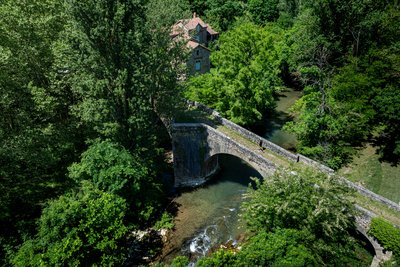
Pont Vieux de Saint-Félix-de-Sorgues - Xavier Waerzeggers  History and heritage
Old Bridge of Saint-Félix-de-Sorgues
The Old Bridge, a true masterpiece of medieval architecture, is one of the symbols of Saint-Félix-de-Sorgues. Stretching about 70 meters, this humpback bridge features three semicircular arches, including a main arch supported by sturdy piers with triangular cutwaters upstream and widened downstream buttresses that create small pedestrian refuges.
Its carefully crafted masonry and precisely assembled vaults likely date from the late 13th or early 14th century. Listed in the national heritage inventory but not formally protected as a historic monument, the bridge now requires maintenance work to preserve both its beauty and structural integrity.
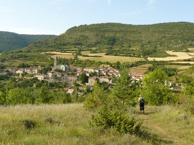
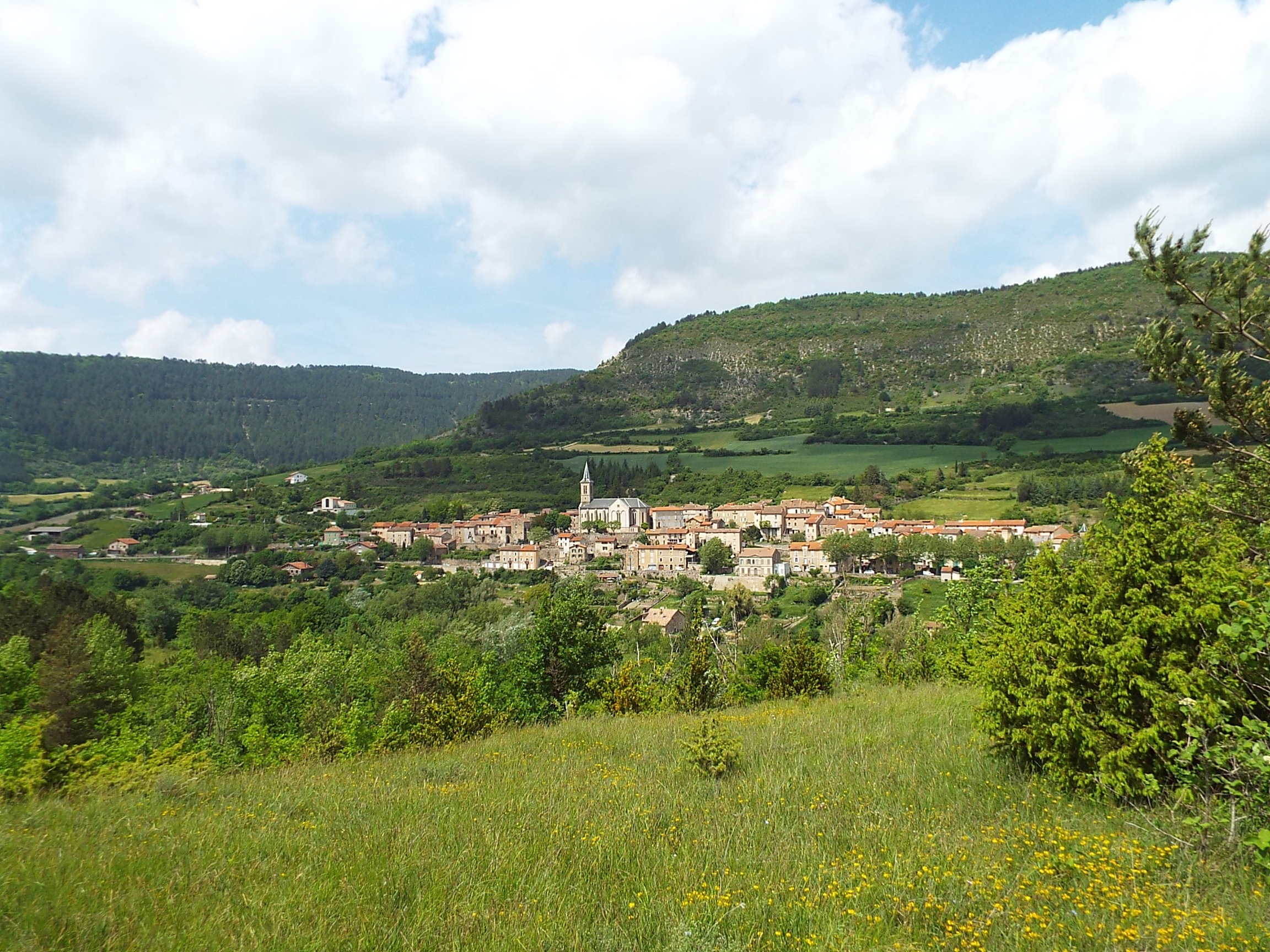
Vue sur Saint-Félix-de-Sorgues - Roquefort Tourisme  Panorama
View over the village of Saint-Félix-de-Sorgues
Perched halfway up the hillside, Saint-Félix-de-Sorgues offers a picturesque view of the surrounding landscape. The village still preserves traces of its medieval fortifications, including a gate, a tower with Gothic openings, and numerous old houses that bear witness to its long history.
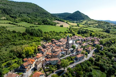
Village de Saint-Félix-de-Sorgues - Xavier Waerzeggers History and heritageVillage of Saint-Félix-de-Sorgues
Saint-Félix-de-Sorgues is home to the remains of the former commandery of the Knights Hospitaller of the Order of Saint John of Jerusalem, built around 1150 and destroyed during the Wars of Religion in the 16th and 17th centuries. This historic site, located south of the church rebuilt in the 19th century, reveals the ruins of two towers and a curtain wall still visible on the southern side of the 1438 fortified enclosure. The Saint-Jean Gate, the only surviving original entrance, recalls the grandeur and complexity of this once-prosperous site, whose records mention holdings as far as Béziers.
Description
This circuit is part of the "4 chemins, 1 école" series which was carried out by the schools in the Sorgues valley in partnership with the CDRP and the municipal councils in the valley (Versols-et-Lapeyre, Saint-Felix-de Sorgues, Marnhagues-et-Latour).
- Park your car on the parking lot opposite the school, along the D 7 road. Leave the car park towards the West and take the calade (a road paved with cobblestones) which slopes down Southward. Turn to the left, then to the right towards the bridge. As you cross the bridge, notice the old mill and the Metasequoia (a resinous tree planted along the left bank of the riverside).
- Take the path to the right then turn left in the curve to follow the ascending track. Make good use of a flat area to enjoy the scenic view over the village. Continue in the same direction through a few buissières (passages lined up with box-trees). During the spring and summer seasons, notice the numerous wild orchids. At the intersection, make a right turn on a descending trail. Leave the tarred track that slopes down to the right and ford the small brook.
- Before entering St Caprazy, take the right track. You can walk through this ancient hospitallers hamlet which houses the workshop of a wood turner. Carry on the communal path that runs along the hamlet, then walk downhill towards the North. Ford the brook and follow a rising path.
- Take the tarred track to the left, walk back to the old bridge to cross it. At the foot of the bridge, take to the left. Head towards the North-West, leave the calade to the right. Notice the old mill in front of which you pass. Follow the calade rising up between gardens (catch sight of pools called « sompes » which serve as a watering system). Walk across the D7 road and climb the stairs.
- Follow the rue du Revelin where remains of battlements of the ancient Hospitallers Commandery can be seen. Walk through the St-John gate, turn to the right and notice the village spring. Leave the Tourelle square to the right and walk down immediately to the righ (catch sight of a beautiful wisteria!)
- Walk down the stairs and take left towards the washing place. Carry on your way and leave one after the other two small roads sloping down to the right. Opposite the schoolyard, turn to the right and walk back to the carpark.
- Departure : Car park opposite the school in Saint-Félix-de-Sorgues
- Arrival : Car park opposite the school in Saint-Félix-de-Sorgues
- Towns crossed : Saint-Félix-de-Sorgues
Forecast
Altimetric profile
Information desks

Avenue de Lauras, 12250 Roquefort/Soulzon
Situated in the Grands Causses Regional Natural Park, the cheese village of Roquefort stretches on the hillside over the famous scree of the Combalou Rock, in southern Larzac. The village is at an elevation of 630 m and has 700 inhabitants.
OPENING PERIODS:
The Tourist Office is open all year round:
- In July and August, Monday to Saturday: 9.30 to 18.30, Sunday: 10.00 to 17.00.
- April, May, June, September, October; Monday to Saturday: 9.30 to 12.15 & 13.00 to 17.30, closed on Sunday.
- January, February, November, December; Monday to Friday: 9.30 to 12.15 & 13.00 to 17.00, closed on Saturday and Sunday.
Transport
Getting around by bus or by train: https://lio.laregion.fr/
Carsharing: BlaBlaCar, Rézo Pouce, Mobicoop, Idvroom, LaRoueVerte, Roulez malin
Access and parking
From Saint-Affrique, follow the road D7 towards Cornus. Saint-Félix-de-Sorgues is located next to Versols-et-Lapeyre.
Parking :
More information
Source

Report a problem or an error
If you have found an error on this page or if you have noticed any problems during your hike, please report them to us here: