N°7 The relays
A long and challenging circuit with steep slopes to cycle up and down and some more technical parts providing a great variety of terrains: paths through the undergrowth, on the red soils or along the former railway line
5 points of interest
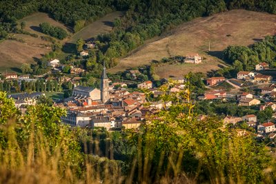
Village de Vabres l'Abbaye - Virginie Govignon  History and heritage
Village of Vabres l’Abbaye
Perched near the confluence of the Dourdou and Sorgue rivers, Vabres-l’Abbaye is a village with a rich religious heritage. Founded in 862 by Benedictine monks, its abbey quickly became a major center in southern Rouergue. In 1317, Pope John XXII made it the seat of a new diocese, leading to the construction of the cathedral. Despite the fires of the Wars of Religion and the upheavals of the Revolution, Vabres has retained its historical significance: in 1875, the church was officially recognized as a cathedral, and the village regained its honorary title of a city, a living testament to its religious and political legacy.
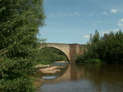
Pont Vieux de Vabres l'Abbaye - Roquefort Tourisme  Small heritage
Pont Vieux in Vabres l’Abbaye
Built in 1278 upstream from the village, the Pont-Vieux, also known as the Old Bridge of Bethlehem, is a landmark structure. It takes its name from the Bethlehem chapel, located on the right bank of the Dourdou downstream from the bridge and listed as a historic monument. This was most likely the site where the Peyralbe toll was collected. Easily recognizable by its humpbacked shape, the bridge features four semicircular arches reinforced with triangular cutwaters. Blown up in 1944, it was later restored identically and is still in use today, including for vehicle traffic.
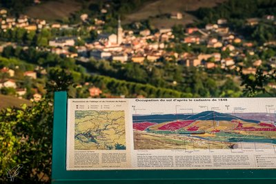
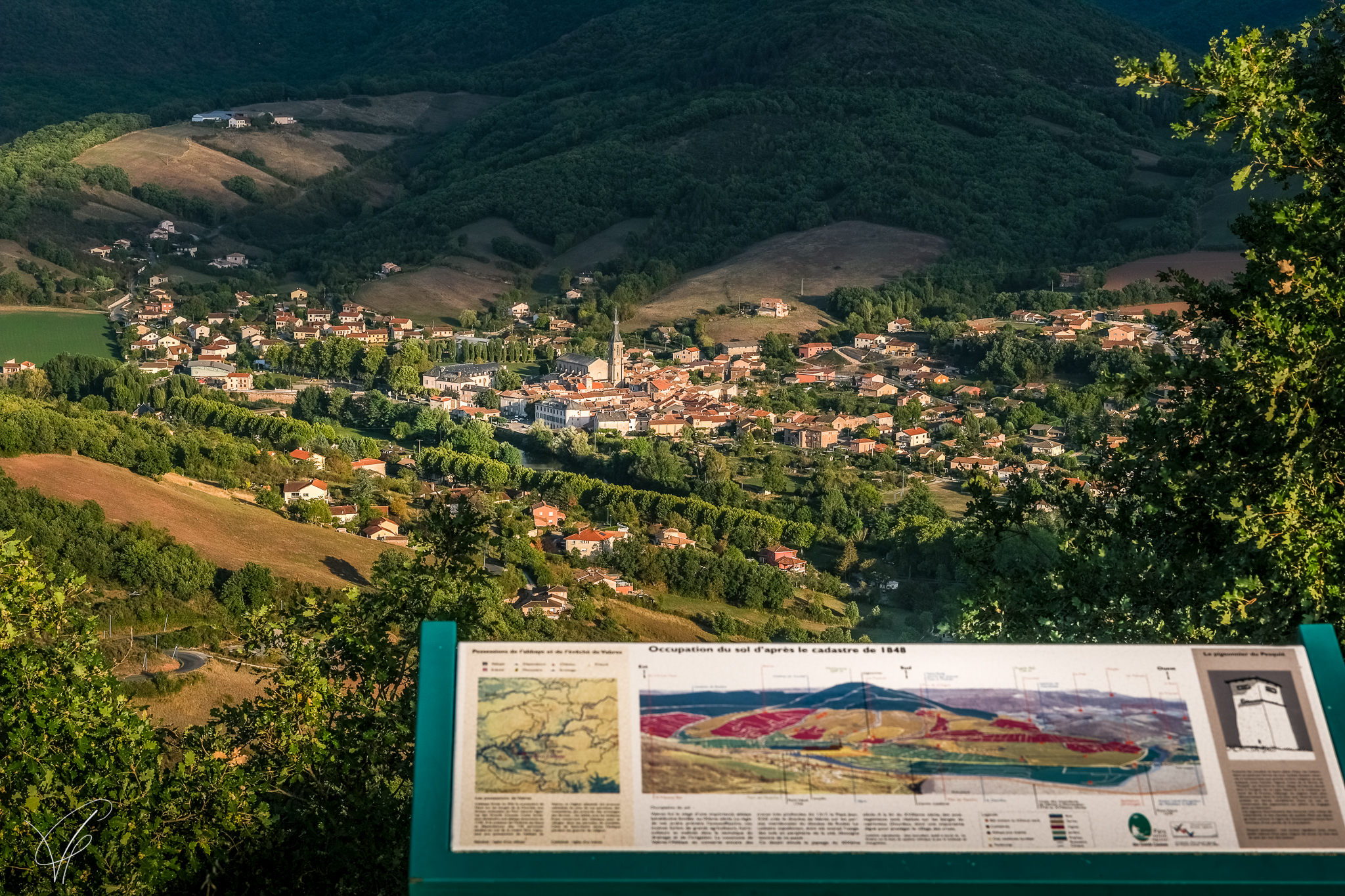
Table d'interprétation de Peyralbe - Virginie Govignon  Panorama
Peyralbe Interpretation Table
Offering a 360° panoramic view, the Peyralbe interpretation table allows visitors to discover the Rougier de Camarès. Thanks to two detailed orientation panels, visitors can learn more about the region’s geology and history, including the formation of a spectacular horseshoe-shaped meander carved by the Dourdou River. The second panel also highlights the village of Vabres-l’Abbaye and its bishopric, founded in 1135.
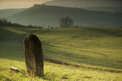
Statue-menhir de Bournac - David Potron  Carved standing stones
Statue-menhir of Bournac
The Menhir statue of Bournac was discovered in 1980 by J. Caumes. This fragment of Permian sandstone measures 0.64 m high and 0.56 m wide, but the complete statue was estimated to reach 1.50 m. On the front, it is engraved with the right hand, a chevron-patterned belt, and two joined legs, suggesting a seated figure. The back shows only the belt.
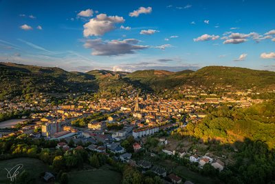
Vue sur Saint-Affrique - Virginie Govignon PanoramaView over Saint-Affrique
At the end of the day, this viewpoint offers an exceptional panorama over the town of Saint-Affrique, perfect for capturing beautiful photos in soft, warm light.
Description
As you cycle along the boulevard A. Briand, go past the EDF building, then turn to your right and follow the road towards Vabres l’Abbaye. This road is a former railway line and leads you to a tunnel. After you have passed through the tunnel, take a left turn on to the D999 and follow it for 200 m.
- Then turn right towards the shopping area and cycle through the hamlet of le Bourguet.
- Cycle under the bridge and join Vabres l’Abbaye. Head towards the Pont Vieux and cross the river.
- Immediately after the bridge, take a path to your left situated between the river and the greenhouses. Pass under the D999, and eventually you will reach the Miral farm. Cycle up the slope for 4 km until you reach Canteloup. Here you can enjoy the beautiful view over the Rougiers de Camarès and the Monts de Lacaune.
- At the intersection, carry straight on along a red soil path running north.
- When you reach the next intersection, take a right, then the first left on to the D117 up to the Mas de Nicouleau. A path takes you above the building to join the crest line up to Peyralbe. You will see the relay and a natural heritage indicator board located at the 524 m vertical benchmark. Retrace your way back down the way you came and then cycle towards Boussy, le Poujol and then follow the former railway line up to the village of le Cambon. Cycle through le Cambon towards Bournac. This village is built out of red stone and clings to the steep hill side.
- Cross the Dourdou river and take the road to the right that leads to Solages.
- (7)Follow the D54 to the left, cycling down the slope and then take the path to your right through an oak wood up the la Pale pass (608 m).
- (8)Retrace your way back by taking the road to your right that leads to Touloupi. 1.5 km further on you will see a path which will bring you back to Saint-Affrique.
- Panoramic view from the TV relay (4km cycling there and back)
- Departure : Saint -Affrique
- Arrival : Saint -Affrique
- Towns crossed : Saint-Affrique, Vabres-l'Abbaye, and Calmels-et-le-Viala
Forecast
Altimetric profile
Recommandations
A few road crossings require you to be careful because of the heavy traffic such as the one situated right at the start of the circuit across the D999.
Box tree moths are active from May to October. During the caterpillar phase, they feed on the leaves of box trees. They crawl down trees and move on long silken threads, although these threads are annoying when hiking they do not pose any health risk
Information desks

Saint-Affrique Tourist Office
Boulevard Aristide Briand, 12400 Saint-Affrique
OPENING TIMES:
The Tourism Office is open all year round, the opening hours are:
·July and august:
From Monday to Saturday: 9h – 13h & 15h – 19h
Sunday: 9h – 13h
·From September to June:
From Tuesday to Saturday: 9h – 13h & 14h – 17h
Closed: Sundays, Mondays and bank holidays
From November to April, the office is also closed on Saturday afternoon.
Transport
Travel by bus or train: http://www.mobimipy.fr/
Carpooling : BlaBlaCar, Rézo Pouce, Covoiturage-libre, Idvroom, LaRoueVerte, Roulez malin
Access and parking
Saint-Affrique is situated 31 km South West from Millau via the D992 and D999 roads.
When driving from Clermont-Ferrand or Montpellier via the A75, take exit n°46, then follow the road D999 up to Saint-Affrique.
From Toulouse/Albi follow the road D999 up to Saint-Affrique.
Parking :
More information
Report a problem or an error
If you have found an error on this page or if you have noticed any problems during your hike, please report them to us here: