Tournemire hiking circuit
Starting from Tournemire, walk across a majestic setting made of limestone rocks and grey marls and try to identify bird and butterfly species that have found refuge in the area - the Rock Swallow, the Red-billed Chough, the Large Blue – and plant species clinging to the cliffs such as Hormathophylla macrocarpa... A walk through a haven of biodiversirty!
4 points of interest
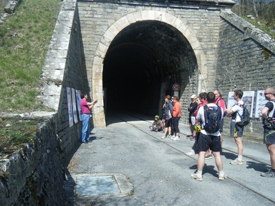
Entrée du tunnel de Tournemire - Joël Atché  History and heritage
Tournemire tunnel
Dug at the end of the 19th century over a length of 1,885 meters, the Tournemire tunnel became a laboratory of the Institute for Radiological Protection and Nuclear Safety (IPSN) in 1988. Research conducted here investigates geology, geophysics, and hydrogeochemistry to better understand the movement of water and the transfer of dissolved substances.
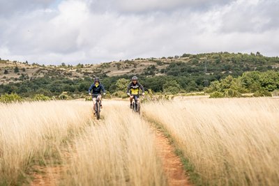
Pelouses sèches - Xavier Waerzeggers  Agropastoralism
Dry Grasslands
An iconic feature of the Grands Causses landscape, the dry grasslands are the result of centuries of interaction between people and nature. Originating from ancient forests gradually transformed by clearing, grazing, and cultivation, they now support an exceptional biodiversity, including many rare plant and animal species. These open spaces also provide hunting grounds for birds nesting in the surrounding cliffs and gorges.
In late spring, the causses are covered with feather grass whose long stems sway in the wind like a silvery mane. The landscape also bears witness to a long pastoral tradition, with stone clearance heaps (clapas), shepherds’ shelters (jasses), and, a little further on, a traditional livestock watering pond known as a lavogne.
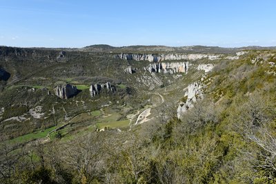
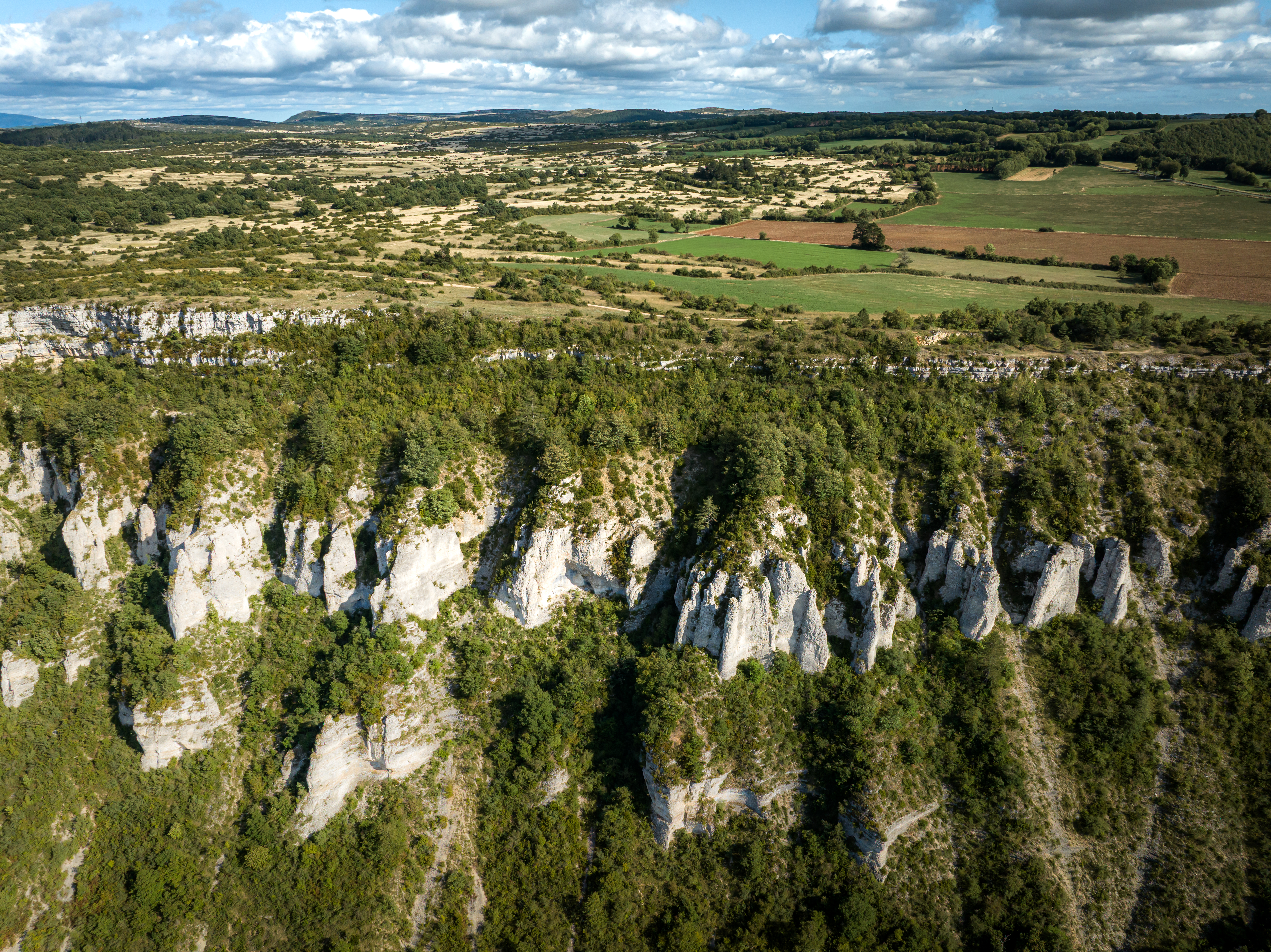
Le cirque de Tournemire - Claude Chambaud  Geology
The Tournemire cirque
Situated in the southwest of the Larzac Causse, the Tournemire Cirque is a remarkable geological area marking the bondary beetwen the fore-causses and the great causses. It presents limestone ledges and rocky escarpments with caves and cavities where raptors such as the eagle owl and the golden eagle nest.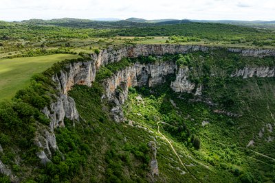
Le Cirque de Tournemire - Xavier Waerzeggers GeologyTournemire Cirque
Designated as a Natura 2000 site, the Tournemire Cirque is one of the most remarkable geological landmarks on the western edge of the Larzac plateau. Its dark marl slopes contrast strikingly with the towering limestone and dolomitic cliffs above. Shaped by erosion over thousands of years, this spectacular landscape features dramatic rock formations that attract both geology enthusiasts and hikers seeking breathtaking scenery.
Description
- Starting from the car park at the Tournemire town hall, walk along the D23 towards Roquefort. 20 m before the passageway that goes under the railway, take the tarmac track on your right up to the old railway tunnel entrance. Follow the yellow marks and turn to the right on a footpath. Go through a fence, then after 100 m cross a path and keep following the ascending track opposite “the engineer trail”. Once you’ve reached the top of a steep slope, turn into a small dry canyon and after 150 m enjoy a magnificent view on your left. Keep going until you reach the Causse du Larzac where the Fournials fortified farm can be seen (private property, visits not allowed).
- Leaving the Fournials farm on your left, take the track to the right towards the Viala du Pas de Jaux. From here, a possible option is to walk onwards for 300 m and just before a small stone building leave the track and take right a footpath that goes directly down to Tournemire.
- Keep following the caussenard footpath and walk past a lavogne (natural pond with a paved bottom on your left) then carry on along the amphitheatre up to the Grépounac cross.
- Retrace your steps back to the fork with the Arnals path.
- Take left the track with a red and white marking (GR71C). Carry on the GR which goes down the Tournemire amphitheatre. Walk your way down to the Pont du Diable where you will see the brook Brias resurgence.
- Head back to Tournemire on the trail, then onto a road which passes the side of the stadium (on the right hand side) then past a beautiful building which was formerly a convent, come back to the Town Hall car park.
- Departure : Town Hall car park situated in the village centre, avenue Hippolyte Puech, in Tournemire.
- Arrival : Town Hall car park situated in the village centre, avenue Hippolyte Puech, in Tournemire.
- Towns crossed : Tournemire, Roquefort-sur-Soulzon, Saint-Rome-de-Cernon, and Viala-du-Pas-de-Jaux
Forecast
Altimetric profile
Recommandations
Travel by bus or train: http://www.mobimipy.fr/
Carpooling : BlaBlaCar, Rézo Pouce, Covoiturage-libre, Idvroom, LaRoueVerte, Roulez malin
Information desks

Avenue de Lauras, 12250 Roquefort/Soulzon
Situated in the Grands Causses Regional Natural Park, the cheese village of Roquefort stretches on the hillside over the famous scree of the Combalou Rock, in southern Larzac. The village is at an elevation of 630 m and has 700 inhabitants.
OPENING PERIODS:
The Tourist Office is open all year round:
- In July and August, Monday to Saturday: 9.30 to 18.30, Sunday: 10.00 to 17.00.
- April, May, June, September, October; Monday to Saturday: 9.30 to 12.15 & 13.00 to 17.30, closed on Sunday.
- January, February, November, December; Monday to Friday: 9.30 to 12.15 & 13.00 to 17.00, closed on Saturday and Sunday.
Transport
Travel by bus or train: https://lio.laregion.fr/
Carpooling : BlaBlaCar, Rézo Pouce, Mobicoop, Idvroom, LaRoueVerte, Roulez malin
Access and parking
Coming from Saint-Affrique or from Millau, take the D999, then follow the D23 towards Tournemire for 6 km
Parking :
Accessibility
More information
Source

Report a problem or an error
If you have found an error on this page or if you have noticed any problems during your hike, please report them to us here: