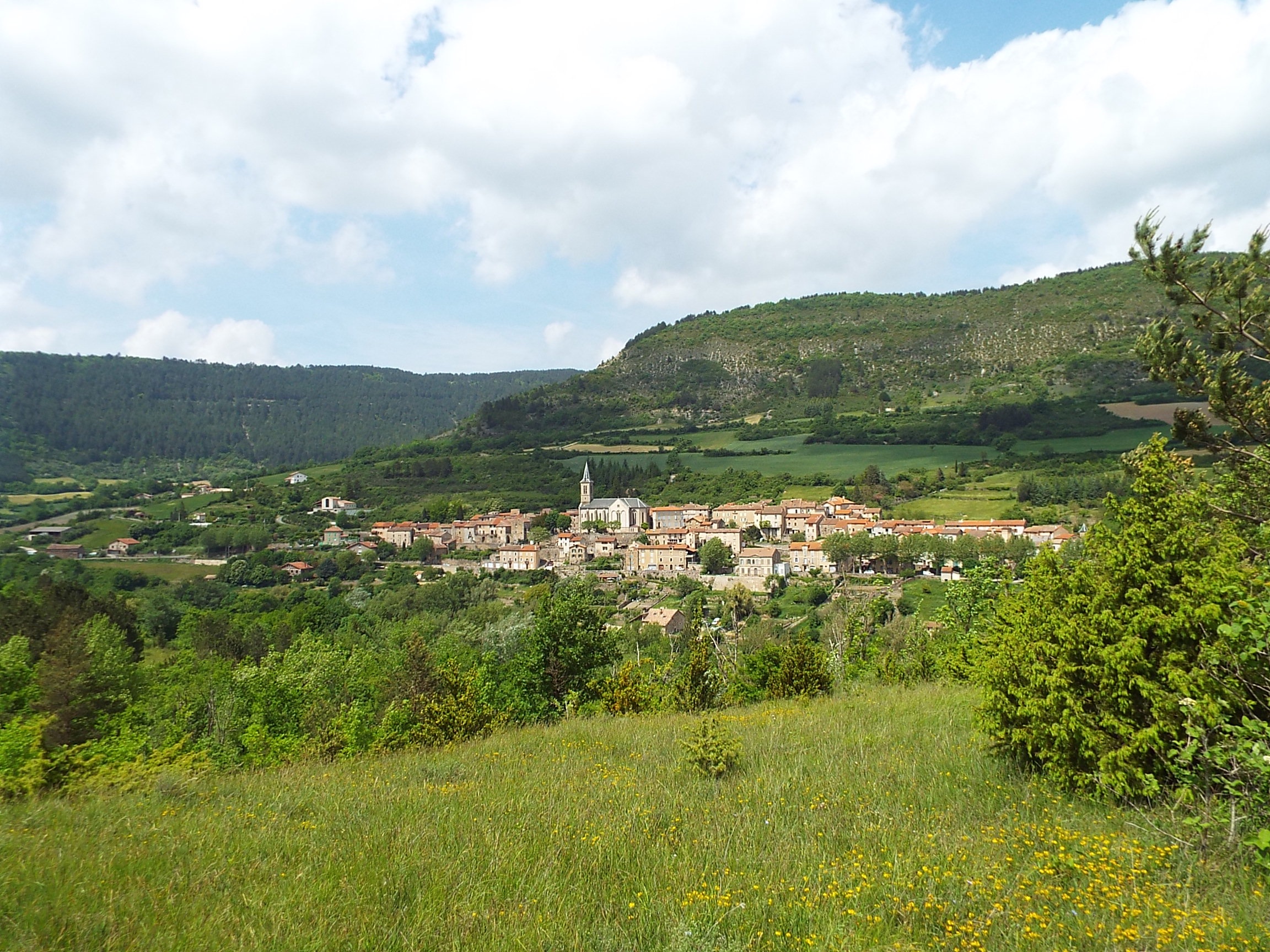
The circuit is scattered with an astonishing array of heritage buildings, serving as landmarks and accompanying you throughout your discovery of these landscapes that has been shaped by the Templar and Hospitaller history and by the agro-pastoral tradition: fortified village, dolmens, buissières, shepherd’s hut, stone cross, Borie farm, medieval hamlet of Saint-Caprazy. This circuit is the third leg of the path that runs throughout the pays du Roquefort.
3 points of interest
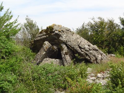
Dolmen Mascourbe 1 - PNR des Grands Causses  Dolmen
Mascourbe dolmen 1
The Mascourbe dolmens belong to the so-called “Treilles” group, named after the cave near the Treilles farm in Saint-Paul-des-Fonts. These prehistoric communities of the Grands Causses were known for their expertise in copper working and for practicing skull trepanation.
This dolmen, partially damaged, still retains an impressive trapezoidal end slab, a testament to these millennia-old constructions.
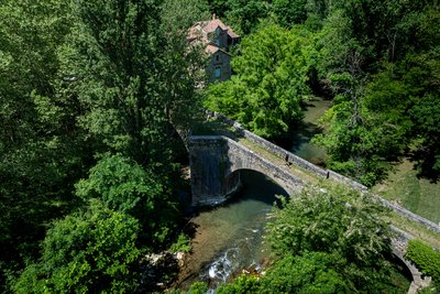
Pont Vieux de Saint-Félix-de-Sorgues - Xavier Waerzeggers  History and heritage
Old Bridge of Saint-Félix-de-Sorgues
The Old Bridge, a true masterpiece of medieval architecture, is one of the symbols of Saint-Félix-de-Sorgues. Stretching about 70 meters, this humpback bridge features three semicircular arches, including a main arch supported by sturdy piers with triangular cutwaters upstream and widened downstream buttresses that create small pedestrian refuges.
Its carefully crafted masonry and precisely assembled vaults likely date from the late 13th or early 14th century. Listed in the national heritage inventory but not formally protected as a historic monument, the bridge now requires maintenance work to preserve both its beauty and structural integrity.
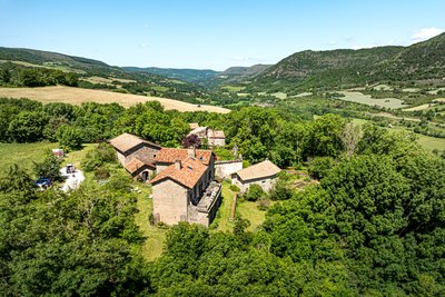
Hameau médiéval de Saint-Caprazy - Xavier Waerzeggers History and heritageSaint-Caprasy Estate
Recorded as early as 1026, Saint-Caprazy is an important historic site in Saint-Félix-de-Sorgues. Around 1150, Gaubert de Saint-Caprazy became the first commander of the Knights Hospitaller of Saint John in Saint-Félix, who maintained their authority there for more than six centuries.
This medieval hamlet still includes several buildings: a dwelling house, a barn, a sheepfold, a chapel, and other agricultural structures, all bearing witness to its rural and religious past.
Description
Walk along the St Jean d’Alcas fort by heading west.
- At the first intersection take left a small descending road. The road then runs uphill. Leave the right road and in a left hand curve take opposite the first bouissière in the direction of Mascourbe via the dolmens.
- Soon you will make out on your right a cazelle in good condition. A bit further on, the path runs across a cultivated field and nearby, the beautiful building of Ramondenc is worth seeing. The path rises on the Causses and reaches the 2 dolmens of Mascourbes.
- Enjoy the beautiful view over the Lévezou, the Larzac, the Escandorgue, and the Montagne Noire. As you reach a small road, take it on your left to walk past the Borie which is an ancient farm of the Hospitaller Commandery in St Félix. At the signboard indicating Mascourbe, just before the first house, take left into the bouissière which leads to the plateau.
- At the junction with a trail, take the trail to the right. 500 m further on the trail reaches a power line, fork to the left to come up to the stone cross of Mascourbe which overlooks the Sorgues valley. Walk by the main trail down to the bottom of the Cantillergues dale.
- Just before entering the village of St Félix, the trail turns into a sunken path that runs to the centre of the village. St Félix is an ancient Hospitaller Commandery and has kept evidences of its past: fountain, washing place, St Jean gate, battlements, covered passages, heritage house and 13th century Old bridge. From the ancient inn, take the calade (road paved with cobblestone) that runs down to gardens and the Sorgues river. Cross the bridge over the river and take the small road to the right towards St Caprazy for approximately 700 m, then in a left curve take right the path that leads to St Caprazy (ancient medieval hamlet). The path crosses a first trail, then a second one just before joining the Vareilhes farm.
- Before reaching Vareilhes take left into the splendid bouissière that goes up to the Loubière. Once you’ve reached the Loubiètre pass, take the trail to your right and immediately after walk downhill to the left to reach the Bâtisse farm. Walk down to the right to reach the D540 after the Mas Nau and take right that road for 500 m.
- Before the small car park, take a track which starting point is not clearly visible and which runs down after a curve on the left side of the road, throughout a field first, then along a hedge. Ford the Vernhes brook. Reach the Combalou hamlet, walk downhill to the right to join the D540. After the bridge take the road to the left, pass through the hamlet of Rigal before reaching Sylvanès
- Towns crossed : Saint-Jean-et-Saint-Paul, Saint-Félix-de-Sorgues, and Sylvanès
Forecast
Altimetric profile
Recommandations
Information desks

Avenue de Lauras, 12250 Roquefort/Soulzon
Situated in the Grands Causses Regional Natural Park, the cheese village of Roquefort stretches on the hillside over the famous scree of the Combalou Rock, in southern Larzac. The village is at an elevation of 630 m and has 700 inhabitants.
OPENING PERIODS:
The Tourist Office is open all year round:
- In July and August, Monday to Saturday: 9.30 to 18.30, Sunday: 10.00 to 17.00.
- April, May, June, September, October; Monday to Saturday: 9.30 to 12.15 & 13.00 to 17.30, closed on Sunday.
- January, February, November, December; Monday to Friday: 9.30 to 12.15 & 13.00 to 17.00, closed on Saturday and Sunday.
Transport
To get more details click on: site internet de l'Office de Tourisme and on Occitanie Transports
There is a bus station in St Affrique (lines 202, 2016, 2018) and a railway station in Tournemire (regional line).
Access and parking
To get to Saint-Jean d'Alcas via A75 (coming from Montpellier or Clermont-Ferrand), take exit 48 towards Cornus and when reaching Fondamente, turn to the right on D 93 towards Roquefort, 12 km further turn left to arrive to Saint Jean d'Alcas.
From Albi/Saint-Affrique and Millau rejoin D999, then D293 (between Saint-Affrique and Lauras) towards Saint-Jean d'Alcapiès. Follow this road for 7 km then turn right to arrive to Saint Jean d'Alcas.Parking :
Report a problem or an error
If you have found an error on this page or if you have noticed any problems during your hike, please report them to us here: