Dolmens walking tour
Once across the Sorgues river in Saint-Affrique, go hiking in the footsteps of our ancestors and crisscross a land which has a high concentration of megaliths. Six dolmens, Neolithic sepulchral chambers mark this journey into the past: dolmens of Touloupy, Boussac East, Boussac West, Crassous Puech, Ibilié, and finally the most majestic: the listed dolmen of Tiergues.
8 points of interest
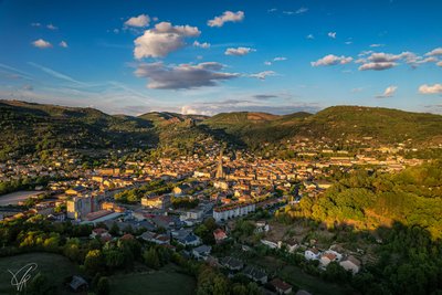
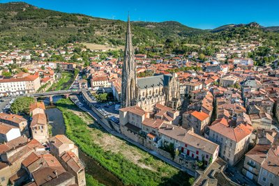
Vue sur Saint-Affrique - Virginie Govignon  Panorama
View over Saint-Affrique
At the end of the day, this viewpoint offers an exceptional panorama over the town of Saint-Affrique, perfect for capturing beautiful photos in soft, warm light.
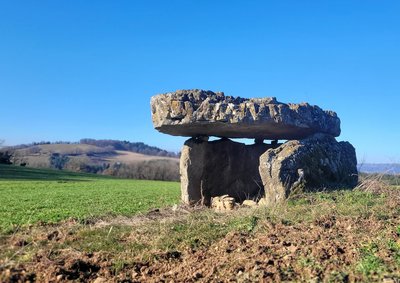
Dolmen de Touloupy - Roquefort Tourisme  Dolmen
Touloupy dolmen
With nearly 1,000 dolmens, Aveyron is the French department with the highest number of these prehistoric monuments. Contrary to popular belief, they were not built by the Celts, but by Neolithic communities more than 4,500 years ago.
The word “dolmen,” meaning “stone table” in Breton, refers to prehistoric collective burial sites. Located 300 meters from the Touloupy farm, this restored dolmen overlooks a small plateau and still retains all the charm of these ancient monuments, fascinating witnesses to the prehistory of the Roquefort region.
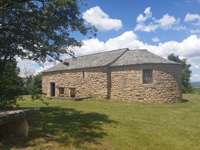
Chapelle St Martin de Boussac - Roquefort Tourisme  History and heritage
Boussac chapel
St Martin’s chapel dates back to the 10th century, and was the main church of the parish of Boussac. It is located on top of a mound which is 650 m high and was renovated in 1999 by a local association. Once a year, around August 15, an open air mass is celebrated, gathering between 200 to 300 parishioners and friends.
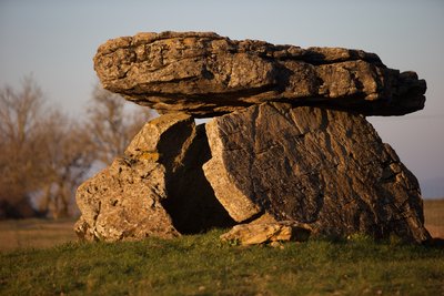
Dolmen de Crassous - Roquefort Tourisme DolmenCrassous Dolmen
With nearly 1,000 dolmens, Aveyron is the French department with the highest number of these monuments. Contrary to popular belief, they were not built by the Celts, but by Neolithic communities more than 4,500 years ago.
The word “dolmen,” meaning “stone table” in Breton, refers to prehistoric collective burial sites. Visible from the road, this dolmen, along with the one at Tiergues, is well worth a visit. Nicknamed “l’Ercoulé,” it is linked to a local legend claiming that the demi-god Hercules, known for his superhuman strength, built this burial site.
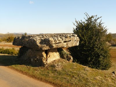
Dolmen de Tiergues - David Potron DolmenTiergues dolmen
With nearly 1,000 dolmens, Aveyron is the French department with the highest number of these prehistoric monuments. Contrary to popular belief, they were not built by the Celts, but by Neolithic communities more than 4,500 years ago.
The word “dolmen,” meaning “stone table” in Breton, refers to prehistoric collective burial sites. Listed as a historic monument, the Tiergues dolmen is one of the most remarkable in Aveyron. Explored in the 20th century by archaeologist Émile Cartailhac, it bears witness to the beliefs and funeral practices of our distant ancestors. Nestled in a preserved natural setting, this site offers a true journey into the heart of prehistory.
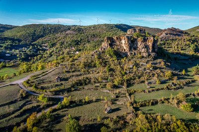
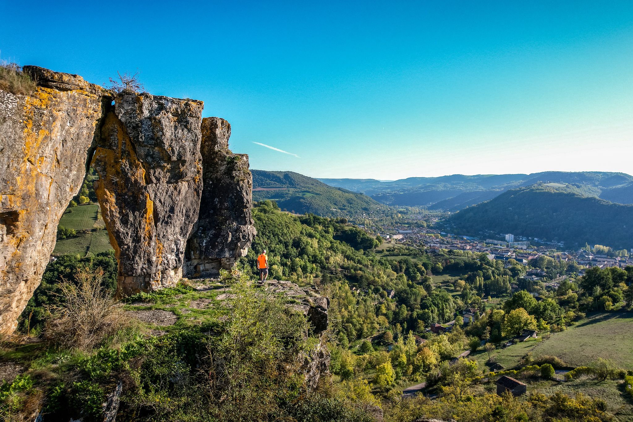
Rocher de Caylus - Virginie Govignon History and heritageThe Rock of Caylus
Perched at an altitude of 519 meters, the Rock of Caylus once supported the castle of the Counts of Caylus, built in the 11th century. Destroyed in 1238, the castle was the heart of a fortified complex that protected the local population. In 1808, the last remaining sections of the fortifications were dismantled to make way for the road to Tiergues. This site reveals a lesser-known chapter of Aveyron’s feudal history and power struggles.
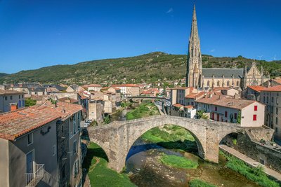
Le Pont Vieux - Virginie Govignon History and heritageThe Old Bridge of Saint-Affrique
Listed as a historic monument, the Old Bridge is one of the most beautiful medieval bridges in France, documented as early as 1408. With its bold yet elegant design, it spans the river with a central arch measuring 21.4 meters, flanked by two smaller arches. Built with a humpback profile and supported by slender triangular piers, it perfectly illustrates the skill of medieval builders. A true landmark of Saint-Affrique, this architectural gem offers a journey back in time through the city’s history.
Ville de Saint-Affrique - Virginie Govignon History and heritageTown of Saint-Affrique
The name Saint-Affrique, with its two “F’s,” often raises curiosity. Its origin dates back to the 5th century, when Arian Visigoths were persecuting Catholic Christians. Africanus, a bishop exiled from Comminges, is said to have taken refuge near the Sorgues River, where he preached to the local population and performed various miracles – a story depicted in the stained-glass windows of the Church of Our Lady of Mercy. The name Saint-Affrique, attested as early as 942 in the archives of Vabres l’Abbaye, may come from the Visigothic term “Affric” or “Effric,” meaning “powerful and fearsome.”
Anecdote : during the French Revolution, the town was briefly renamed “Montagne sur Sorgues” to remove any religious reference, as was common practice at the time.
Description
- From the carpark, walk along the Pont-Neuf which spans the river Sorgues. Just after the bridge turn left at a hairpin bend to join the right bank of the Sorgues. Turn right to walk up an ascending trail "la Carrierasse" that leads to a narrower path rising up the mountain side called "travers des Cazes". Join the tarred road.
- After the Escarbassols, leave the road and turn right, then left on a dirt road. Make your way through the undergrowth following a northwest direction. Walk down towards the Riviéral ravine and continue on by climbing over a fence where you will find a wide trail with a hairpin bend. Keep going uphill towards the plateau along a hedge bordering a steep field. Join a service road and reach a junction. Turn to your right to reach the chapel.
- Retrace your way back to the road that leads to Boussac. Turn to the right, then first left and follow a dirt road for 1.5 km.
- Join the road which leads to Boussac. When you get to the intersection with the Nougayrolles road take the path opposite lined with box trees which leads to the fourth dolmen, the walk there and back takes less than fifteen minutes. Retrace your steps and take the road back towards Crassous. Just a little before the quarry, notice a well preserved dolmen to your right.
- At the entrance of the hamlet, leave the road and follow a stony trail to the left that runs between some houses. Wind your way down a twisting path and join the D 50 then the D 250 roads. Keep walking on this road for 250m and walk to the left through a “Buissière” which runs parallel to the road. Take a Causse pathway that first connects to the road, then leads to the Baldassé cross. Carry on this path Eastward up to the Tiergues dolmen.
- Follow the trail to the southwest running between meadows and thickets to meet a “buissière”. Carry on along this trail, then on a descending path through the Gardies ravine. Join the trail that connects Saint-Affrique to Tiergues.
- Walk to the right along the Nougayrolles ravine. Pass a sheepfold, then head straight on up to a junction with the path coming from ridges.
- Walk down towards the rocher de Caylus, pass around a rocky outcrop that leads to the road. Find a track to the left, then a narrow path overlooking the D 993. Join the road and retrace your way back to the town centre.
Take care when fording the brook and climbing over the fence.
- Departure : Foch square
- Arrival : Foch square
- Towns crossed : Saint-Affrique and Saint-Rome-de-Tarn
Forecast
Altimetric profile
Recommandations
Box tree moths are active from May to October. During the caterpillar phase, they feed on the leaves of box trees. They crawl down trees and move on long silken threads, although these threads are annoying when hiking they do not pose any health risk
Information desks

Avenue de Lauras, 12250 Roquefort/Soulzon
Situated in the Grands Causses Regional Natural Park, the cheese village of Roquefort stretches on the hillside over the famous scree of the Combalou Rock, in southern Larzac. The village is at an elevation of 630 m and has 700 inhabitants.
OPENING PERIODS:
The Tourist Office is open all year round:
- In July and August, Monday to Saturday: 9.30 to 18.30, Sunday: 10.00 to 17.00.
- April, May, June, September, October; Monday to Saturday: 9.30 to 12.15 & 13.00 to 17.30, closed on Sunday.
- January, February, November, December; Monday to Friday: 9.30 to 12.15 & 13.00 to 17.00, closed on Saturday and Sunday.
Transport
Travel by bus or train: https://lio.laregion.fr/
Carpooling : BlaBlaCar, Rézo Pouce, Mobicoop, Idvroom, LaRoueVerte, Roulez malin
Access and parking
Saint-Affrique is situated on the RD 999 road axis which links Millau to Albi.
Parking :
More information
Source
Report a problem or an error
If you have found an error on this page or if you have noticed any problems during your hike, please report them to us here: