Notre Dame de Grace
From the village of Saint-Izaire, reach the opposite bank and ascend to Notre-Dame-de-Grâce, a restored medieval shrine that overlooks the Dourdou plain. A carved standing stone and the native home of Canon Hermet who was an expert on the subject, delineate this heritage loop which also follows an old railway.
3 points of interest
Village de Saint-Izaire - Virginie Govignon  History and heritage
Village of Saint-Izaire
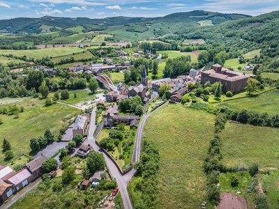
Saint-Izaire is a fortified village whose history is closely linked to its episcopal castle, the former summer residence of the bishops of Vabres. Mentioned as early as 862, the village gradually surrounded itself with ramparts during the 12th century to protect its inhabitants from feudal conflicts.
After the Wars of Religion, the fortifications lost their defensive role: openings were made in the walls, and some fortified gates were altered to allow carts to pass and houses to expand. Despite these changes, the layout of the streets, alleys, and houses has remained almost unchanged since the Middle Ages. The 15th- and 16th-century façades and windows still give the village its historic charm today.
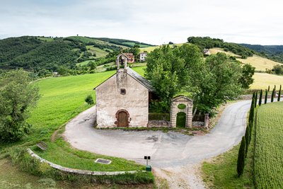
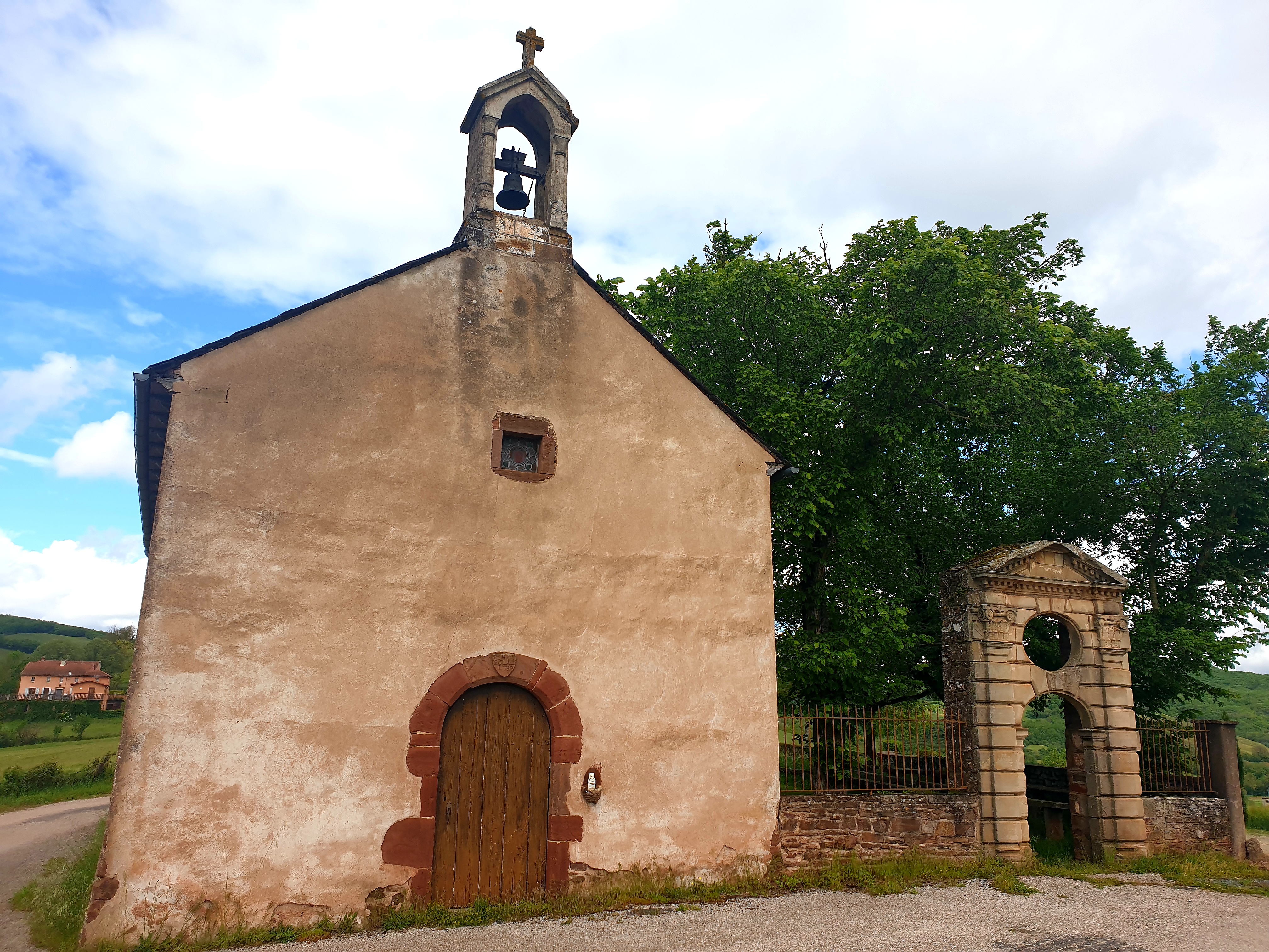
Chapelle Notre Dame de Grâce - Xavier Waerzeggers History and heritageChapel of Our Lady of Grace
Overlooking the southern bank of the Dourdou River, the Chapel of Our Lady of Grace is an emblematic site of Saint-Izaire. Mentioned as early as 1461 under the name “Notre-Dame de l’Ouradou,” it was restored in 1730 before being sold as national property during the French Revolution and later converted into a sheepfold. Restored again in the 19th century, it now incorporates architectural elements from the former castle and old village church.
For many years, the chapel housed a relic believed to have protective and healing powers, especially against skin diseases and respiratory illnesses, and for the protection of pregnant women and newborns. These beliefs left a strong mark on local memory, making the chapel a symbol of protection for the village.
This tradition continues today through annual pilgrimages, particularly on August 15th.
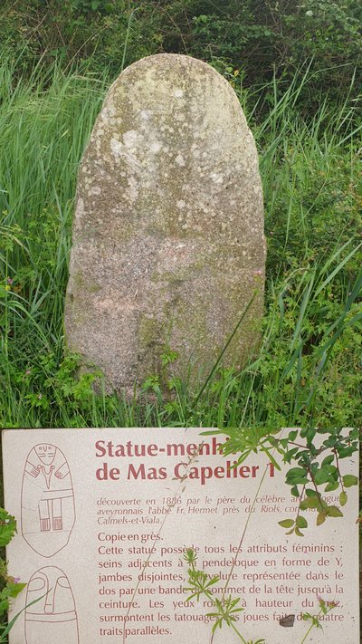
Statue-menhir du Mas Capelier - Roquefort Tourisme  Carved standing stones
Mas Capelier Statue-Menhir
This female statue-menhir stands out for the fine detail of its engravings: breasts, legs, hairstyle, and tattoo-like patterns adorn this prehistoric figure. A true testament to ancient art, it illustrates how femininity was represented in Neolithic cultures.
This moving monument is one of the earliest expressions of artistic and symbolic creation by human societies in the Causses region.
Description
- The starting point is the Place de la Bascule (carpark under the bridge), cross the bridge.
- At the roundabout take to the left towards Broquiès. After approximately 50 m, head directly to the almost only tricky part of this walking route: a 100 m long steep path that leads to the foot of ND de Grâces Chapel. At the rear of the chapel, you will find a small enclosed area to relax and enjoy a scenic view over the village and the plain. A pilgrimage, well known in the region, takes place every year (nowadays, on August 15th) with an open air mass which is celebrated in the enclosed area.
- Carry on to the left towards the former hôtel Bellevue, leave the tarred road to ascend straight on the path called « chemin du château d’eau ».
- Keep walking until you reach a carved standing stone to the right, a notice board displays the history of the statue. Then, carefully follow the marking signs, for here several tracks head in all directions. The one which is to be followed is the most to the right, it is narrow, uneven, runs downhill and goes back to the Dourdou plain.
- Next, follow to the right the ancient railway until you reach a junction again on the right that rises to the chapel. Enjoy once more the view over the plain.
- Then retrace your way back to the starting point.
- Departure : Place de la Bascule, Saint-Izaire (carpark under the bridge)
- Arrival : Place de la Bascule, Saint-Izaire (carpark under the bridge)
- Towns crossed : Saint-Izaire and Calmels-et-le-Viala
Forecast
Altimetric profile
Recommandations
Box tree months are active from May to October. During the caterpillar phase, they feed on the leaves of box trees. They crawl down trees and move on long silken threads, although these threads are annoying when hiking they do not pose any health risk
Information desks

Avenue de Lauras, 12250 Roquefort/Soulzon
Situated in the Grands Causses Regional Natural Park, the cheese village of Roquefort stretches on the hillside over the famous scree of the Combalou Rock, in southern Larzac. The village is at an elevation of 630 m and has 700 inhabitants.
OPENING PERIODS:
The Tourist Office is open all year round:
- In July and August, Monday to Saturday: 9.30 to 18.30, Sunday: 10.00 to 17.00.
- April, May, June, September, October; Monday to Saturday: 9.30 to 12.15 & 13.00 to 17.30, closed on Sunday.
- January, February, November, December; Monday to Friday: 9.30 to 12.15 & 13.00 to 17.00, closed on Saturday and Sunday.
Transport
Travel by bus or train: https://lio.laregion.fr/
Carpooling : BlaBlaCar, Rézo Pouce, Mobicoop, Idvroom, LaRoueVerte, Roulez malin
Access and parking
From Millau, follow the D992, then the D999 up to Vabres l’Abbaye, from Albi, follow the D999 up to Vabres l’Abbaye. Once in the village, proceed to the West via the D25. Saint-Izaire is located 16 km from Vabres l’Abbaye.
Parking :
More information
Report a problem or an error
If you have found an error on this page or if you have noticed any problems during your hike, please report them to us here: