The Tiergues dolmen
Following valleys and ridges, throughout buissières and Scotch pine forests, this looped hiking trail is accessible to all and invites you to reach two outstanding stone remains located in the Saint-Affrique region. A pleasant trip back in time… and into geological strata: from the Permian Basin in Saint-Affrique to the limestones and dolostones in the frontal Causses area.
2 points of interest
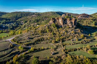
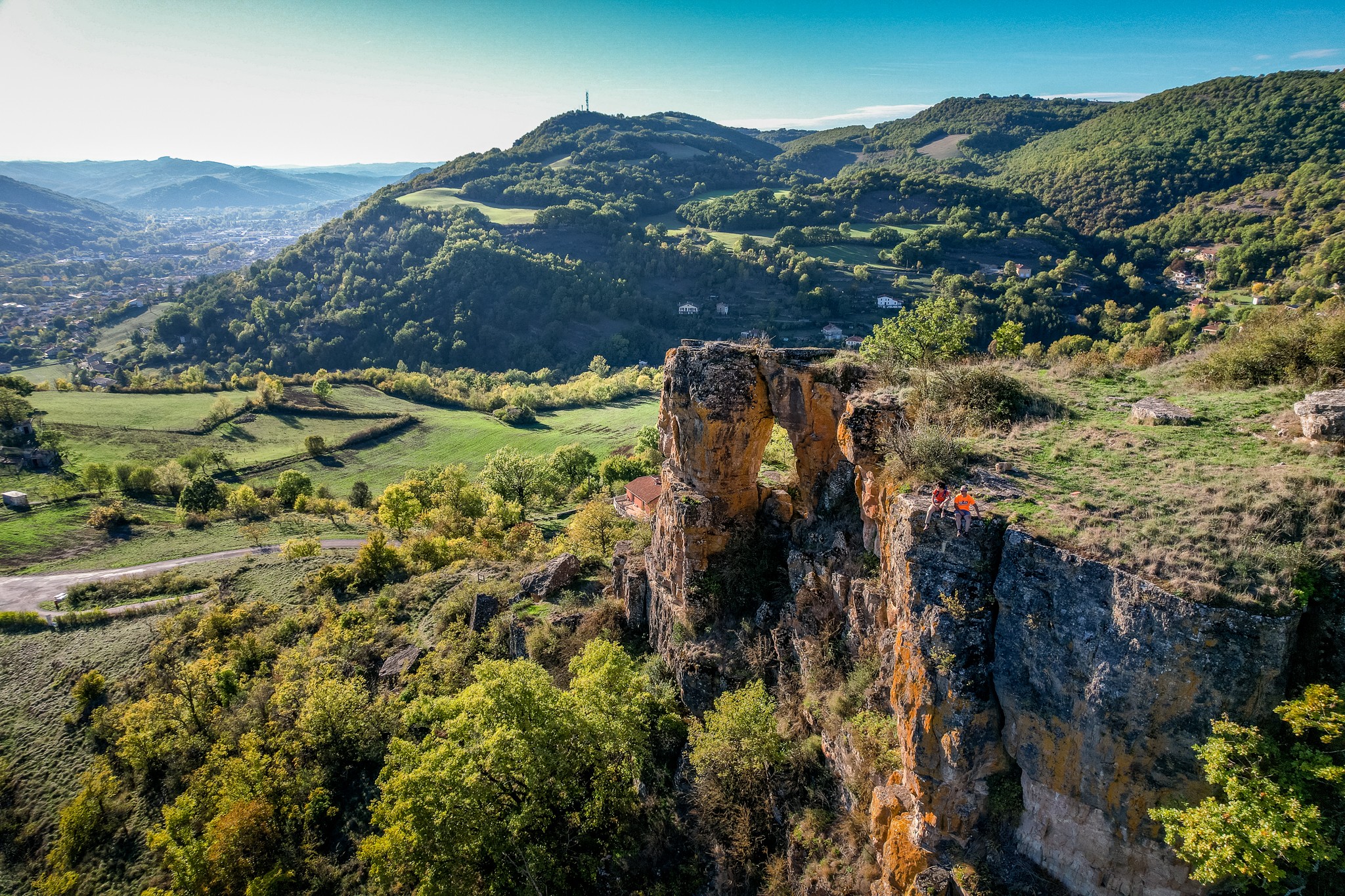
Rocher de Caylus - Virginie Govignon  History and heritage
The Rock of Caylus
Perched at an altitude of 519 meters, the Rock of Caylus once supported the castle of the Counts of Caylus, built in the 11th century. Destroyed in 1238, the castle was the heart of a fortified complex that protected the local population. In 1808, the last remaining sections of the fortifications were dismantled to make way for the road to Tiergues. This site reveals a lesser-known chapter of Aveyron’s feudal history and power struggles.
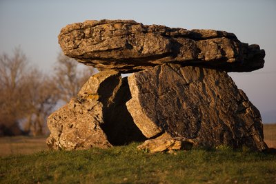
Dolmen de Tiergues - David Potron  Dolmen
Tiergues dolmen
With nearly 1,000 dolmens, Aveyron is the French department with the highest number of these prehistoric monuments. Contrary to popular belief, they were not built by the Celts, but by Neolithic communities more than 4,500 years ago.
The word “dolmen,” meaning “stone table” in Breton, refers to prehistoric collective burial sites. Listed as a historic monument, the Tiergues dolmen is one of the most remarkable in Aveyron. Explored in the 20th century by archaeologist Émile Cartailhac, it bears witness to the beliefs and funeral practices of our distant ancestors. Nestled in a preserved natural setting, this site offers a true journey into the heart of prehistory.
Description
1 Start from the Painlevé square and follow the D 993 for 100m, then take the left turn under the porch and follow the stone pathway. Carry on along the road on the right hand side, up to the start of the bend, then walk straight on along the path in front of you and then follow a larger track that takes you back onto the road.
2 Take the right turn onto the stone pathway that runs around the base of Caylus rock. Take the path towards the NE which slopes gently upwards and overlooks the D 993 which is to your right.
3 Take the left track that runs in the valley parallel to the D 50. The walk is a shady path alongside the ravine and the Nougayrolles brook. Leave the farm trail to your right that ascends towards the crest and the path to your left which leads towards Crassous. After the sheepfold the path gets wider and reaches a junction.
4 Take the path that slopes up through woodland and ends at a plateau, nearby the Tiergues dolmen. Walk on the right side of the D 250 alongside the road, and then carry on along a sheep path until you reach the village of Tiergues. Take the road to the right along the graveyard and then walk through the village.
5 When you pass the last houses and reach the calvary cross, take the path opposite which is lined with low walls and hedges. Follow a long “bouissière” (a path lined with box trees) which ends at the crest of the hill where you can enjoy a nice view over Saint-Affrique and the Caylus rock. Carry on along the crest through pasture lands and groves, then go through a cedar plantation, and eventually walk down towards the Caylus rock passing a cliff to your right.
3 From here, follow the route you took back to your starting point.
- Departure : From de tourist office reach the Painlevé square
- Arrival : Return your way back to the tourist office
- Towns crossed : Saint-Affrique
Forecast
Altimetric profile
Recommandations
The path is steep at the Caylus rock and on the crest before n°3.
Box tree moths are active from May to October. During the caterpillar phase, they feed on the leaves of box trees. They crawl down trees and move on long silken threads, although these threads are annoying when hiking they do not pose any health risk
Information desks

Saint-Affrique Tourist Office
Boulevard Aristide Briand, 12400 Saint-Affrique
OPENING TIMES:
The Tourism Office is open all year round, the opening hours are:
·July and august:
From Monday to Saturday: 9h – 13h & 15h – 19h
Sunday: 9h – 13h
·From September to June:
From Tuesday to Saturday: 9h – 13h & 14h – 17h
Closed: Sundays, Mondays and bank holidays
From November to April, the office is also closed on Saturday afternoon.
Transport
Travel by bus or train: https://lio.laregion.fr/
Carpooling : BlaBlaCar, Rézo Pouce, Mobicoop, Idvroom, LaRoueVerte, Roulez malin
Access and parking
Saint-Affrique is located 31 km from Millau and is accessible from roads D 992 and D 999
Parking :
More information
Report a problem or an error
If you have found an error on this page or if you have noticed any problems during your hike, please report them to us here: