

A getaway to the Causse between Larzac and Dourbie
Over 68 km of a challenging route await you, across the Larzac plateau – which is more rugged than it appears – as well as through the foothills of the plateau, carved by valleys. The route offers a whole range of technical challenges, not to mention the need to pace yourself over the long distance. Five villages – including three founded by the Knights Templar and the Order of Hospitallers – and a hamlet mark this exhilarating route through the heart of the great outdoors.
1 point of interest
Chemin de ronde vu intérieure - Point Accueil La Cavalerie  History and heritage
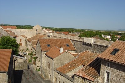
The ramparts of La Cavalerie
The fortifications of La Cavalerie, a centuries-old work against the test of time…
Situated at the north of the Larzac plateau, La Cavalerie was created in the 12th century by the Templars of Sainte-Eulalie commandery, settled on the Larzac Causse since 1152.The Sainte-Marie church (1180) was included in the Knights Templars dwelling and included several buildings around a small courtyard. The village developed around this building, where the inhabitants found refuge in case of danger.
However, this protection as well as that of the Commandery of Sainte-Eulalie was considered insufficient during the Hundred Years War, where the Larzac, a wide open plateau, badly defended but provided with cattle, attracted the people of war. The commander of Sainte-Eulalie, Bertrand d’Arpajon, fortified the important places of his commandery: Le Viala du Pas de Jaux in 1430, then La Cavalerie, La Couvertoirade in 1439 and finally Sainte-Eulalie in 1442.
Source : Point accueil La Cavalerie.
Description
- From L’Hospitalet-du-Larzac, start the route on the RD23 heading west towards Viala-du-Pas-de-Jaux. At the ‘Quatre Routes’ crossroads, turn right onto the RD77, then right again onto the RD277.
- From there, head towards La Cavalerie by turning right onto the RD999. Pass through this village, once home to the Knights Templar and the Order of St John, following the ramparts, before turning right onto the small Route de la Tune. This stretch, approximately 5 km long, offers your first taste of the Causse landscapes. Just before a secluded farm, turn right, then left at the next crossroads to rejoin the RD999 at the hamlet of Les Liquisses Hautes.
- Continue eastwards towards the village of Nant. In the centre of the village, pass the Place du Claux and carry on towards Saint-Jean du Bruel. After La Mouline, turn right towards La Couvertoirade. This marks the start of the gradual climb up the Côte de la Fare to the plateau. An ideal section for finding your rhythm on a steady gradient.
- At the top of the hill, near the gatekeeper’s house on the old Tournemire–Le Vigan railway line, take the D7 briefly to the right, then turn left onto the RD55 towards La Couvertoirade. A short detour will allow you to explore this remarkable village, listed among the ‘Most Beautiful Villages of France’. After this cultural detour, get back on the road via the D185 to La Pezade, then continue on the D140.
- A few kilometres further on, pass through the hamlet of Canals. On the right, just before the church, is the Maison du Guilhaumard, which houses an exhibition on the Guilhaumard Sensitive Natural Area. Then take the first road on the right to reach Cornus, a staging post before the final climb.
- In Cornus, at the junction with the D7, continue to the right to pass through the village and begin the final climb, which will take you up onto the Larzac plateau. Pass the junction at the Aire de la Tour d’Aiguillon, then turn left onto the D77 as far as the ‘Quatre Routes’ junction.
- Finally, turn right for the last stretch, which will take you back to L’Hospitalet-du-Larzac, the end point of this challenging loop, combining physical exertion, unspoilt nature and a heritage stretching back a thousand years.
- Departure : L’Hospitalet-du-Larzac
- Arrival : L’Hospitalet-du-Larzac
- Towns crossed : L'Hospitalet-du-Larzac, Sainte-Eulalie-de-Cernon, La Cavalerie, Nant, La Couvertoirade, Les Rives, and Cornus
Forecast
Altimetric profile
Recommandations

Information desks

Tourist Office Larzac et Vallées
Place du Claux, 12230 NANT
Located on the ground floor of the Town Hall (mansion of the 18th century), The Tourist Office welcomes you all year and offers tourist information on the Larzac and its valleys, the department of Aveyron, and also on neighboring counties. Free Wifi access.
Opening hours :
From Novembre to February: Tuesday morning 9:00-12:30
March and October : Tuesday to Friday 9:00-12:30
April : Tuesday to Friday 10:00-12:30 and 14:00-17:30
May, June : Tuesday to Saturday 10:00-12:30 and 14:00-17:30
July and August : every day 09:00-13:00
September : Tuesday to Saturday 10:00-12:30 and 14:00-17:30
Access and parking
Access from the south: A75 motorway, junction 48, L’Hospitalet du Larzac
Access from the north: A75 motorway, junction 47, La Cavalerie, then the RD 809
Parking :

Report a problem or an error
If you have found an error on this page or if you have noticed any problems during your hike, please report them to us here: