The Sargels residual mound
Starting from the village of Saint-Rome-de-Cernon, escalate the Sargel mound and discover a Caussenard built heritage such as a hamlet and a Jasse. This site is an ancient Neolithic human settlement.
From the summit, a superb view over the Grands Causses including the Roquesquatre rock on the southern side can be enjoyed.
1 point of interest

Butte de Sargel - Xavier Waerzeggers  Panorama
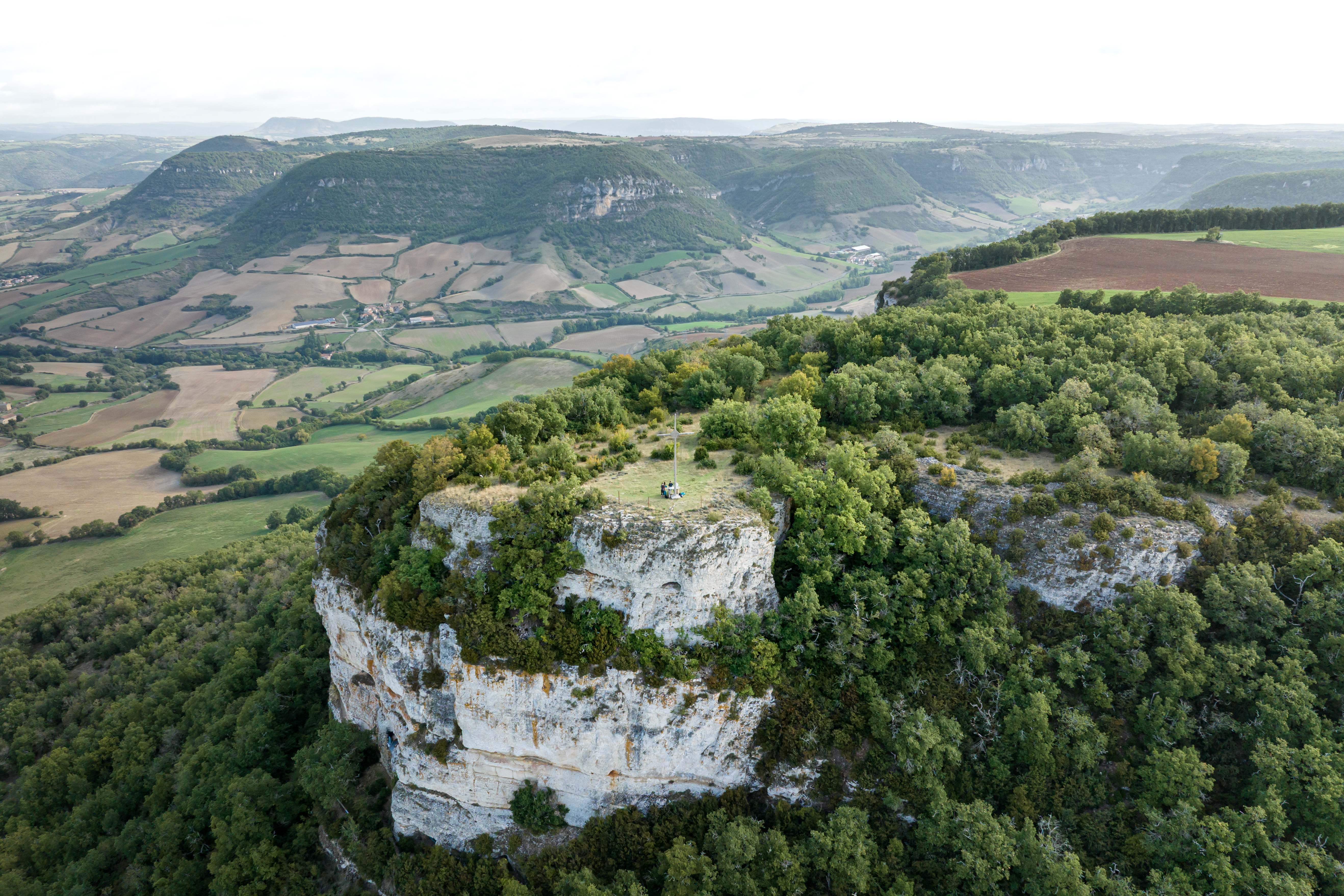
Sargel Hill
Rising to 761 metres above sea level, Sargel Hill is a remarkable butte témoin (erosional outlier), the remnant of a vast plateau that once connected the Larzac with the Taulan, Combalou, and Sargel plateaus. Over millions of years, erosion and the carving of the Cernon, Lavencou, and Soulzon valleys isolated these landforms, preserving traces of the ancient landscapes of the Grands Causses.
Today, the site offers outstanding views of the Lévézou Mountains, the foothills of the Larzac, and the Merdelou peak, providing a striking introduction to the region’s geological heritage.
Description
- On the Southern part of the car park take the rue de la passade up to the end of the street, then turn left to walk across the D999 road and carry on along the Avenue de la Cavalerie where you cross the bridge up to the other end and turn left before the railway line on a road that leads to the stadium (signpost).
- 600 m further on, Just before this bridge, leave the road and take a trail along the railway.After 500 m, pass under a second bridge to cross the railway which you overlook now alongside your way. Carry on northwards until you catch sight of a small house (formerly a crossing-keeper's house) located below left.
- From there, turn sharp right and take the path which ascends the ravine. Leave the path to the right and carry straight on. After 700 m, follow the hair pin bend and continue along an old path lined with dry stone walls which leads to the Cave Basse.
- This path takes you above the swimming pool and turn left between the buildings. Walk along the trail into a “boussière” (a narrow passage defined by two rows of box trees) and join the path coming from the Cave Haute. Take left and just after right. Now, follow the wide trail ascending towards the mound. The slope becomes steeper and follows a series of hair pin bends. After the 6th bend you arrive on the plateau, where you will see a ruined sheepfold on the right. Walk to the left of the fence, and after a wide bend you will reach the calvary where you can enjoy the beautiful landscape of the surrounding plateaus: the Lévézou, Roquesquatre and the Merdélou.
- To return, retrace your way back to the Cave Basse (4). When you reach the swimming pool, take the left path which descends towards a dilapidated old barn: The Batisse.
- The path links up with a small tarmacked road. Follow this road up to the railway. Walk under the bridge that was left aside on the way there (2). Retrace your way back to the car park.
- Departure : Car park opposite the Village Hall
- Arrival : Car park opposite the Village Hall
- Towns crossed : Saint-Rome-de-Cernon and Saint-Georges-de-Luzençon
Forecast
Altimetric profile
Recommandations
Travel by bus or train: http://www.mobimipy.fr/
Carpooling : BlaBlaCar, Rézo Pouce, Covoiturage-libre, Idvroom, LaRoueVerte, Roulez malin
Information desks

Avenue de Lauras, 12250 Roquefort/Soulzon
Situated in the Grands Causses Regional Natural Park, the cheese village of Roquefort stretches on the hillside over the famous scree of the Combalou Rock, in southern Larzac. The village is at an elevation of 630 m and has 700 inhabitants.
OPENING PERIODS:
The Tourist Office is open all year round:
- In July and August, Monday to Saturday: 9.30 to 18.30, Sunday: 10.00 to 17.00.
- April, May, June, September, October; Monday to Saturday: 9.30 to 12.15 & 13.00 to 17.30, closed on Sunday.
- January, February, November, December; Monday to Friday: 9.30 to 12.15 & 13.00 to 17.00, closed on Saturday and Sunday.
Transport
Travel by bus or train: https://lio.laregion.fr/
Carpooling : BlaBlaCar, Rézo Pouce, Mobicoop, Idvroom, LaRoueVerte, Roulez malin
Access and parking
Situated 15 km from Saint-Affrique and 18 km from Millau via the D992 and the D 999 roads.
Parking :
Accessibility
- Emergency number :
- 114
Source

Report a problem or an error
If you have found an error on this page or if you have noticed any problems during your hike, please report them to us here: