2. From the maison de la vigne in Tournemire to St Jean d’Alcas
Prepare to be dazzled by this exquisite get away! Discover the many breathtaking views during your walking through wild and majestic crescent shaped cliffs and your striding across the Knights Hospitallers Larzac overlooked by the Viala-du-Pas-de-Jaux attic-tower. The Cistercian fort of Saint-Jean d’Alcas which is situated at the end of the circuit awaits you. This circuit is the second leg of the path that runs throughout the pays du Roquefort.
7 points of interest
Le Cirque de Tournemire - Xavier Waerzeggers  Geology
Tournemire Cirque
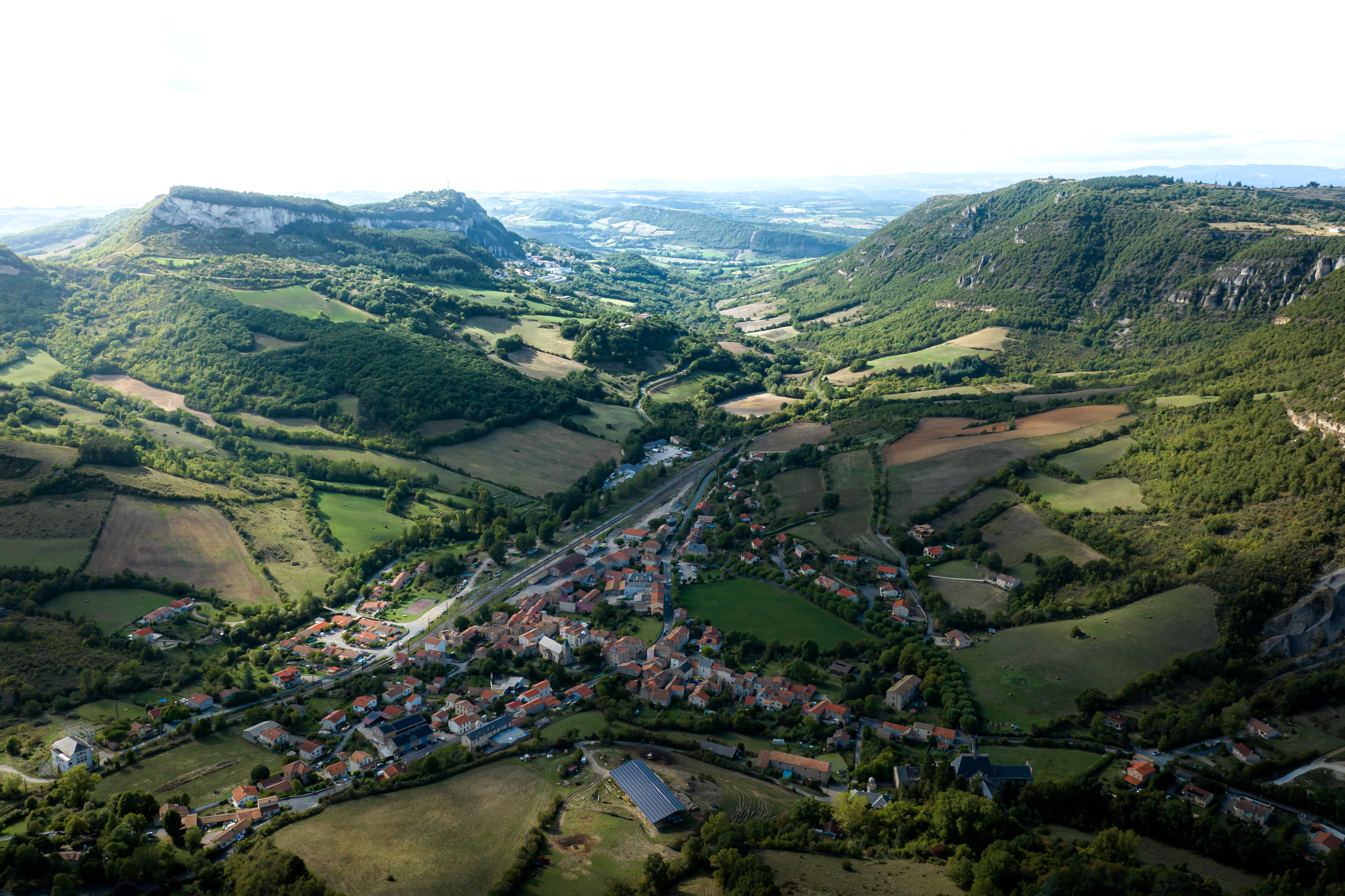
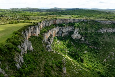
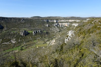
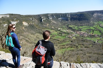
Designated as a Natura 2000 site, the Tournemire Cirque is one of the most remarkable geological landmarks on the western edge of the Larzac plateau. Its dark marl slopes contrast strikingly with the towering limestone and dolomitic cliffs above. Shaped by erosion over thousands of years, this spectacular landscape features dramatic rock formations that attract both geology enthusiasts and hikers seeking breathtaking scenery.
Le cirque de Tournemire - Claude Chambaud GeologyThe Tournemire cirque
Situated in the southwest of the Larzac Causse, the Tournemire Cirque is a remarkable geological area marking the bondary beetwen the fore-causses and the great causses. It presents limestone ledges and rocky escarpments with caves and cavities where raptors such as the eagle owl and the golden eagle nest.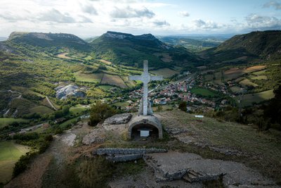
Croix de Gréponac - Xavier Waerzeggers  Panorama
Croix de Gréponac
Perched above the Cirque of Tournemire, the stone Croix de Gréponac is a landmark of the landscape. It offers outstanding panoramic views over the village of Tournemire, the dramatic contours of the cirque, and the surrounding foothills of the Causses, making it an ideal spot to pause and take in the scenery.
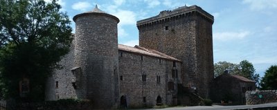
La Tour du Viala - Association La Tour du Viala  History and heritage
Tower of Viala du Pas de Jaux
The Lord of Tournemire gave to the Templars knights the lands of Viala du Pas de Jaux in 1150. In the 12th and 13th centuries, the Viala consisted of a few farms.
After 1312, when the Hospitallers took possession of the Templars’ property, they decided to create in this place a village and for that they built farm buildings, managed by the brothers of the order. They constructed for them a dwelling and a church dedicated to St-Jean-Baptiste, the patron of the Hospitallers.
Until 1430, the inhabitants of Viala du Pas de Jaux and the surroundings took refuge in Ste-Eulalie de Cernon during the periods of insecurity which occurred on the Larzac. Because of the high distance between the two village, the inhabitants asked the authorization to the Grand Prior of Saint Gilles, to build a fortified tower to be able to take refuge inside with their possessions. This is the first fortification built on the plateau.
Today the 30 meters high tower has been restored. The vaulted ground floor, the five floors, its terrace and the dwelling dating from the 14th century are now accessible.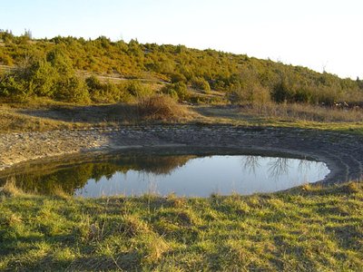
Lavogne de Font Rome - Association La Tour du Viala du Pas de Jaux  Agropastoralism
The lavogne (cobbled watering place)of Font Rome
This lavogne (cobbled watering place) of Font Rome, built in 1910 near tank wells is was first situated on a waterproof clay background. Then, it was built of stones all around and cemented. So this type offers the advantage of forming a passage that resists the trampling of sheep, and the gentle slope of the surrounding area limits the risk of slipping and falling of the animals. It is supplied by rainwater.
Le cirque de Saint Paul des Fonts - Claude Chambaud PanoramaCirque of St-Paul-des-Fonts
The cirque of St-Paul-des-Fonts is a semi-circular natural cirque formed by karst erosion.
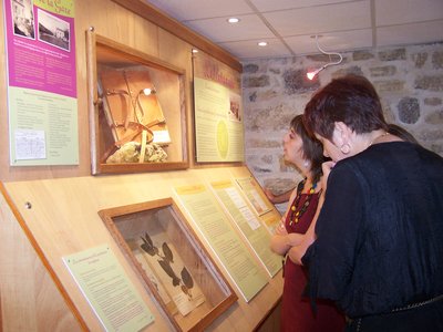
Espace Hippolyte Coste - OT Larzac et Vallées  Flora
FloraBotanical Museum Hippolyte Coste
Established on the ground floor of the presbytery adjoining the church of Saint-Paul-des-Fonts, the botanical space is dedicated to the life and work of the canon Hippolyte Coste who shared his life between the duties of his ministry and his passion for botany.
This rouergate of modest peasant origins, which has been nicknamed "le curé des fleurs" (the priest of the flowers), knew how to rise in the yard of the greatest botanists by realizing in particular the remarkable and masterful «Flore descriptive et illustrée de la France, de la Corse et des contrées limitrophes» (1901 – 1906) which constitutes its masterpiece, known and still recognized today at the European scale.
With this museum Saint-Paul-des-Fonts becomes an unmissable destination for all those who wish to learn by discovering the botanical wealth of the Larzac and Aveyron.
Open from april to septembre. Free entrance.
Description
This leg follows all the GR71C or its alternative
From the maison de la vigne, ford the Brias brook, walk along the disused football pitch
- Get back to the trail that goes to your left towards the back of the amphitheatre. The trail rises progressively before turning into a track that reaches the top of the Tournemire amphitheatre. Walk close to the edge, around the amphitheatre to get to the Grépounac Cross and enjoy the beautiful view over the frontal Causses and the Combalou rock of Roquefort.
- From the cross, head towards the south-east to reach the D23, take this road for 700 m, and then follow the trail on the right that leads to the Viala du Pas de Jaux tower (notice the superb lavogne).
- From the Viala tower, the hiking trail takes the road leading to the Mas Baldy for 200 m. At the cross, turn off the road and take left a wide logging road. Before the first major trail intersection, take right a path, leave a lavogne to the right and carry on the grassy path towards the Mas Baldy. Keep going on the small road of la Fage for 800 m.
- In a curve, take right a path which runs throughout a pastureland and joins a sunken path lined up with box trees. The path leads to the edges of the beautiful amphitheatre of St Paul des Fonts.Walk downhill along a stony path zigzagging on the slopes, cross a brook and carry on towards the village centre.
- In the village of St Paul des Fonts, turn off the GR71C that ascends the plateau to the left and follow the alternative route towards St Jean d’Alcas. Walk along the Annou brook and soon after the village exit, leave the departmental road and take a small road to the right. Cross the railway line (Béziers to Millau) and, just after take right a trail. Keep going on this main trail up to the D 93.
- When reaching the D 93, do not cross the road, but take the path to the left. Cross the road a bit further on and follow a sunken path to reach St Jean d’Alcas.
- Departure : Car par of the Maison du plésiosaure.
- Arrival : Saint-Jean d'Alcas
- Towns crossed : Tournemire, Viala-du-Pas-de-Jaux, and Saint-Jean-et-Saint-Paul
Forecast
Altimetric profile
Recommandations
Information desks

Avenue de Lauras, 12250 Roquefort/Soulzon
Situated in the Grands Causses Regional Natural Park, the cheese village of Roquefort stretches on the hillside over the famous scree of the Combalou Rock, in southern Larzac. The village is at an elevation of 630 m and has 700 inhabitants.
OPENING PERIODS:
The Tourist Office is open all year round:
- In July and August, Monday to Saturday: 9.30 to 18.30, Sunday: 10.00 to 17.00.
- April, May, June, September, October; Monday to Saturday: 9.30 to 12.15 & 13.00 to 17.30, closed on Sunday.
- January, February, November, December; Monday to Friday: 9.30 to 12.15 & 13.00 to 17.00, closed on Saturday and Sunday.
Transport
To get more details click on: site internet de l'Office de Tourisme and on Occitanie Transports
There is a bus station in St Affrique (lines 202, 2016, 2018) and a railway station in Tournemire (regional line).
Access and parking
From Clermont-Ferrand and Montpellier, via the A 75, exit 48, then take the D2009 towards l'Hospitalet, then the D23 towards Tournemire.
From Millau or Saint-Affrique, join the D999 and in Lauras take the D23 towards Roquefort / Tournemire
Parking :
Report a problem or an error
If you have found an error on this page or if you have noticed any problems during your hike, please report them to us here: