4. To get to Saint-Jean d'Alcas via A75 (coming from Montpellier or Clermont-Ferrand), take exit 48 towards Cornus and when reachin
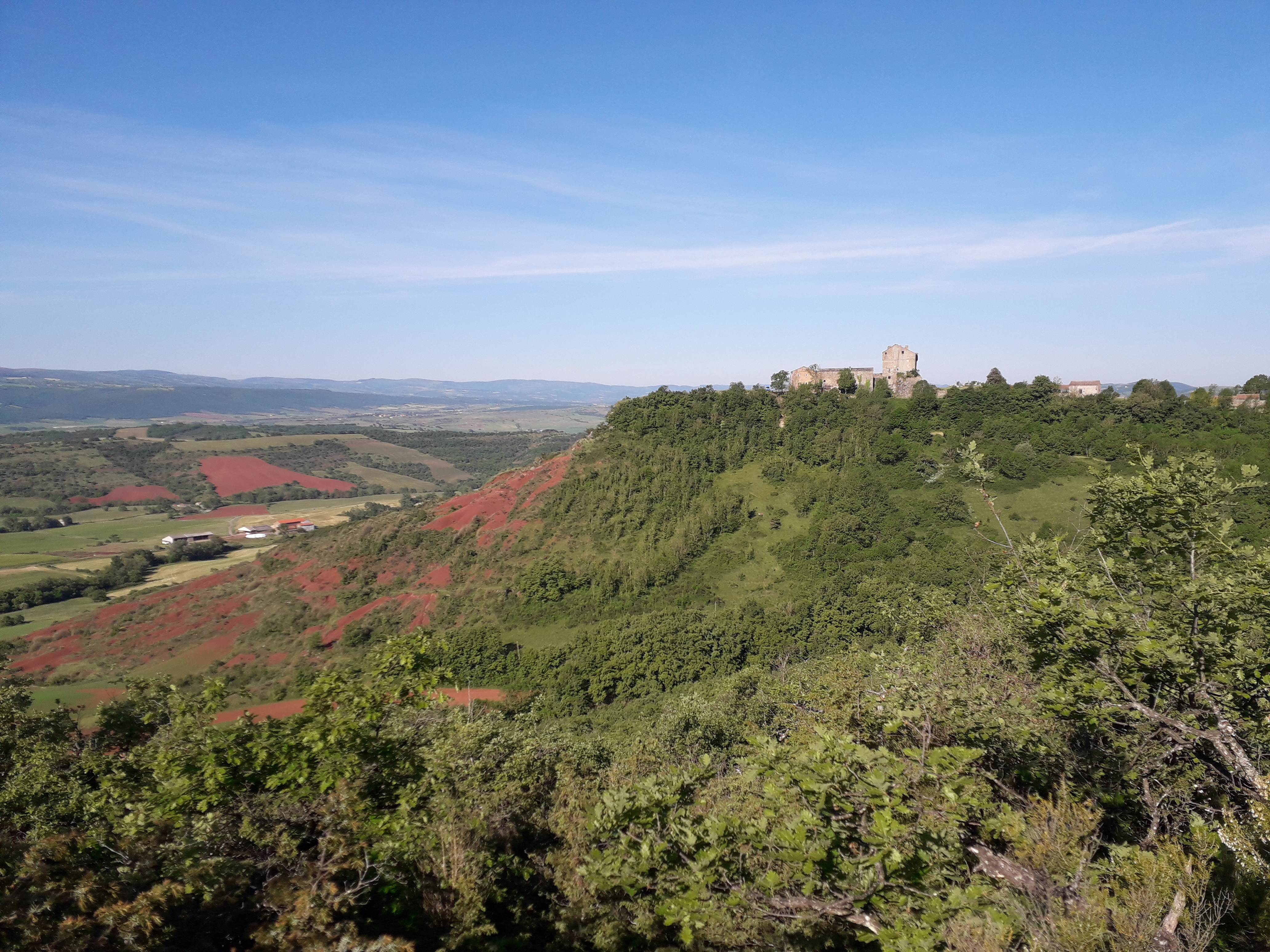
The Cistercian abbey of Sylvanès and the feudal castle of Montaigut are the two main sites of cultural interest during this hike that runs along the foothills of the Loubière plateau and that takes you to the threshold of the Rougier de Camarès, providing outstanding scenic views over the pic du Merdelou and the monts de Lacaune.
This circuit is the fourth leg of the path that runs throughout the pays du Roquefort.
Description
From the village centre of Sylvanès take a small road (between the Town Hall and the restaurant) that leads to Maxels.
- In the hamlet, take the left path and ford the brook twice, walk the ascending path up to a trail intersection.
- Once you have ford across the brook again, take the left trail and walk around the Bataille farm to the right, the trail continues to rise. On the plateau, take the left trail that leads to the road and to the village of Gissac. Enjoy the scenic view over the Rougier de Camarès, the pic de Roste, the Merdelou and the Monts de Lacaune. Walk across the village of Gissac (castle and washing place are worth to be seen) and head towards the Montaigut castle on D105.
- At the exit of the village take right a bouissière that runs down towards the Moulin (formerly a fish farm). Walk across the Moulin and go for approximately 600 m up a small road.
- Before the hamlet of Douzou, take right a track, then at the junction of 4 trails take the one opposite which leads to the Besc hillside catchment reservoir. After the reservoir, take the left trail that gradually rises. Follow this main trail up to a hairpin bend on the right side.
- 100 m after the hairpin bend, take to the left a recently completed pathway (be careful not to miss the trailhead). The path rises zigzagging through the woodland, crosses a 1st trail and joins a 2nd one which is to be followed on the left.
- Approximately 200 m after this intersection, leave the ascending path to the right and follow the contour line. The hike has already provided magnificent views over the Rougier and far in the distance, offered a first vision of the Montaigut castle. Keep walking up to a field, the logging road runs down to the left and goes along a 2nd field.
- You soon leave this path to take a track (cairn) which starts to the right of the field. This track crosses a trail and reaches the abandoned farmhouse of Gaujoux. After the farm, go ahead along the track that turns into a path and follows the contour line towards the Montaigut castle. Keep walking on the main path overlooking the Rougier. This path that crosses the Aigue Lebade ravine has been often hewn out of the rock.
- The path goes along the plaster mill before reaching the Montaigut castle
- Departure : Abbaye de Sylvanès
- Arrival : Château de Montaigut
- Towns crossed : Sylvanès and Gissac
Forecast
Altimetric profile
Information desks

Avenue de Lauras, 12250 Roquefort/Soulzon
Situated in the Grands Causses Regional Natural Park, the cheese village of Roquefort stretches on the hillside over the famous scree of the Combalou Rock, in southern Larzac. The village is at an elevation of 630 m and has 700 inhabitants.
OPENING PERIODS:
The Tourist Office is open all year round:
- In July and August, Monday to Saturday: 9.30 to 18.30, Sunday: 10.00 to 17.00.
- April, May, June, September, October; Monday to Saturday: 9.30 to 12.15 & 13.00 to 17.30, closed on Sunday.
- January, February, November, December; Monday to Friday: 9.30 to 12.15 & 13.00 to 17.00, closed on Saturday and Sunday.
Transport
To get more details, click on: site internet de l'Office de Tourisme and on: Occitanie Transports
There is a bus station in St Affrique (lines 202, 2016, 2018) and a railway station in Tournemire (regional line).
Access and parking
To get to Saint-Jean d'Alcas via A75 (coming from Montpellier or Clermont-Ferrand), take exit 48 towards Cornus and when reaching Fondamente, turn to the right on D 93 towards Roquefort, 12 km further turn left to arrive to Saint Jean d'Alcas.
From Albi/Saint-Affrique and Millau rejoin D999, then D293 (between Saint-Affrique and Lauras) towards Saint-Jean d'Alcapiès. Follow this road for 7 km then turn right to arrive to Saint Jean d'Alcas.
Parking :
Source
Report a problem or an error
If you have found an error on this page or if you have noticed any problems during your hike, please report them to us here: